Zhoutian geodata
Zhoutian (Guangdong) is a seat of a fourth-order administrative division; located in China in Asia/Shanghai (GMT+8) time zone. In our database, there are 1268 cities with bigger population. Compared to other cities in China, 86.5% of cities are located further ↑North; 52.5% of cities are located further →East and 56.1% of cities have higher elevation than Zhoutian. Note1


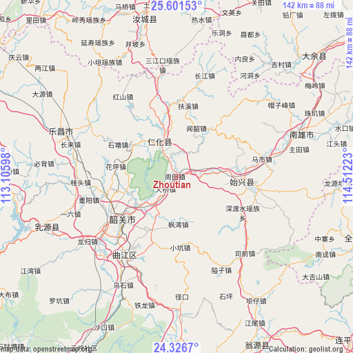
Zhoutian GPS coordinates[2]
24° 57' 56.772" North, 113° 48' 32.76" East
| Map corner | latitude | longitude |
|---|---|---|
| Upper-left | 25.60153°, | 113.10598° |
| Center: | 24.96577°, | 113.8091° |
| Lower-right: | 24.3267°, | 114.51223° |
| Map W x H: | 141.7×141.7 km | = 88×88mi |
| max Lat: | 53.31946° ⇑86.5% North |
| Zhoutian: | 24.96577° |
| min Lat: | ⇓13.5% South 18.22056° |
| min Long | Zhoutian | max Long |
| 75.07348° | 113.8091° | 134.28917° |
| W 47.5%⇐ | ⇒52.5% E |
Elevation
Elevation of Zhoutian is 123 m = 404 ft, and this is 361.8 m = 1187 ft below average elevation for this country.
| Max E: |
5622 m = 18445 ft | 56.1% |
| Avg. | 484.8 m = 1591 ft | |
| Zhoutian | 123 m = 404 ft | |
Min E: |
-3 m = -10 ft | 43.9% |
See also: China elevation on elevation.city.
Geographical zone
Zhoutian is located in North temperate zone (between Tropic of Cancer and the Arctic Circle). Distance of this Northern Tropic circle is 170 km =105.6 mi to South.| Distance of | km | miles | from Zhoutian |
|---|---|---|---|
| North Pole | 7231.1 | 4493.2 | to North |
| Arctic Circle | 4625.2 | 2874 | to North |
| Tropic Cancer | 170 | 105.6 | to South |
| Equator | 2775.9 | 1724.9 | to South |


Nearby cities:
15 places around Zhoutian: (largest is in red/bold)
• Chengnan
25.2 km =15.7 mi,  99°
99°
• Danxia
10.9 km =6.8 mi,  325°
325°
• Daqiao
8.2 km =5.1 mi,  221°
221°
• Datang
24.3 km =15.1 mi,  208°
208°
• Dongtang
22.1 km =13.7 mi,  305°
305°
• Fengwan
18.4 km =11.4 mi,  180°
180°
• Huangkeng
10.4 km =6.5 mi,  5°
5°
• Huaping
24.4 km =15.2 mi,  282°
282°
• Renhua
15.4 km =9.6 mi, 334°
• Shensuo
17.6 km =10.9 mi,  106°
106°
• Shitang
27.2 km =16.9 mi,  296°
296°
• Shixing
25.9 km =16.1 mi,  94°
94°
• Taiping
25.6 km =15.9 mi, 94°
• Wenshao
20.8 km =12.9 mi,  21°
21°
• Xinshao
26 km =16.2 mi,  232°
232°
Sources, notices
• [Note1] Compared only with cities in China existing in our database
• [Src1] Map data: © OpenStreetMap contributors (CC-BY-SA)
• [Src2] Other city data from geonames.org with taken over terms of usage.
• [Src3] Geographical zone / Annual Mean Temperature by Robert A. Rohde @ Wikipedia
