Shanggongma geodata
Shanggongma (Qinghai) is a seat of a fourth-order administrative division; located in China in Asia/Shanghai (GMT+8) time zone. In our database, there are 1268 cities with bigger population. Compared to other cities in China, 69.4% of cities are located further ↓South; 94.7% of cities are located further →East and 99% of cities have lower elevation than Shanggongma. Note1


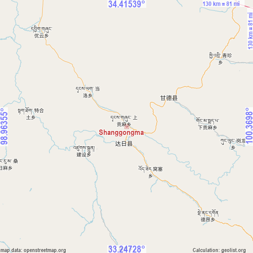
Shanggongma GPS coordinates[2]
33° 49' 59.988" North, 99° 40' 0.012" East
| Map corner | latitude | longitude |
|---|---|---|
| Upper-left | 34.41539°, | 98.96355° |
| Center: | 33.83333°, | 99.66667° |
| Lower-right: | 33.24728°, | 100.3698° |
| Map W x H: | 129.9×129.9 km | = 80.7×80.7mi |
| max Lat: | 53.31946° ⇑30.6% North |
| Shanggongma: | 33.83333° |
| min Lat: | ⇓69.4% South 18.22056° |
| min Long | Shanggongma | max Long |
| 75.07348° | 99.66667° | 134.28917° |
| W 5.3%⇐ | ⇒94.7% E |
Elevation
Elevation of Shanggongma is 4185 m = 13730 ft, and this is 3700.2 m = 12140 ft above average elevation for this country.
| Max E: |
5622 m = 18445 ft | 1% |
| Shanggongma | 4185 m 13730 ft | |
| Avg. | 484.8 m = 1591 ft | |
Min E: |
-3 m = -10 ft | 99% |
See also: China elevation on elevation.city.
Geographical zone
Shanggongma is located in North temperate zone (between Tropic of Cancer and the Arctic Circle). Distance of this Northern Tropic circle is 1156 km =718.3 mi to South.| Distance of | km | miles | from Shanggongma |
|---|---|---|---|
| North Pole | 6245.1 | 3880.5 | to North |
| Arctic Circle | 3639.3 | 2261.4 | to North |
| Tropic Cancer | 1156 | 718.3 | to South |
| Equator | 3761.9 | 2337.5 | to South |


Nearby cities:
15 places around Shanggongma: (largest is in red/bold)
• Dongqinggou
81.6 km =50.7 mi,  19°
19°
• Dêrnang
64.2 km =39.9 mi,  133°
133°
• Ganglong
55.1 km =34.2 mi,  98°
98°
• Gyangqai
77.1 km =47.9 mi,  61°
61°
• Jianshe
29.8 km =18.5 mi,  235°
235°
• Jimai
9.3 km =5.8 mi,  190°
190°
• Kequ
26.3 km =16.3 mi, 55°
• Kyinzhi
59.4 km =36.9 mi,  54°
54°
• Moba
62.9 km =39.1 mi,  182°
182°
• Sangruma
47.7 km =29.6 mi, 244°
• Tanglag
27.3 km =17 mi,  311°
311°
• Tehetu
49.9 km =31 mi,  277°
277°
• Wosai
27.1 km =16.8 mi,  152°
152°
• Xiagongma
46.5 km =28.9 mi, 95°
• Youyun
65.5 km =40.7 mi,  318°
318°
Sources, notices
• [Note1] Compared only with cities in China existing in our database
• [Src1] Map data: © OpenStreetMap contributors (CC-BY-SA)
• [Src2] Other city data from geonames.org with taken over terms of usage.
• [Src3] Geographical zone / Annual Mean Temperature by Robert A. Rohde @ Wikipedia
