Chengxiang geodata
Chengxiang (Guangxi) is a seat of a third-order administrative division; located in China in Asia/Shanghai (GMT+8) time zone. In our database, there are 1268 cities with bigger population. Compared to other cities in China, 93.7% of cities are located further ↑North; 79.5% of cities are located further →East and 58.2% of cities have higher elevation than Chengxiang. Note1


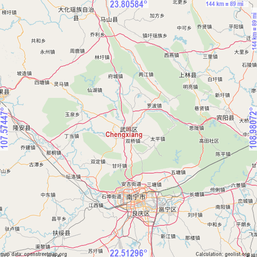
Chengxiang GPS coordinates[2]
23° 9' 39.456" North, 108° 16' 39.324" East
| Map corner | latitude | longitude |
|---|---|---|
| Upper-left | 23.80584°, | 107.57447° |
| Center: | 23.16096°, | 108.27759° |
| Lower-right: | 22.51296°, | 108.98072° |
| Map W x H: | 143.8×143.8 km | = 89.4×89.4mi |
| max Lat: | 53.31946° ⇑93.7% North |
| Chengxiang: | 23.16096° |
| min Lat: | ⇓6.3% South 18.22056° |
| min Long | Chengxiang | max Long |
| 75.07348° | 108.27759° | 134.28917° |
| W 20.5%⇐ | ⇒79.5% E |
Elevation
Elevation of Chengxiang is 110 m = 361 ft, and this is 374.8 m = 1230 ft below average elevation for this country.
| Max E: |
5622 m = 18445 ft | 58.2% |
| Avg. | 484.8 m = 1591 ft | |
| Chengxiang | 110 m = 361 ft | |
Min E: |
-3 m = -10 ft | 41.8% |
See also: China elevation on elevation.city.
Geographical zone
Chengxiang is located in North Torrid zone (between Equator and Tropic of Cancer). Distance of this Northern Tropic circle is 30.7 km =19.1 mi to North.| Distance of | km | miles | from Chengxiang |
|---|---|---|---|
| North Pole | 7431.8 | 4617.9 | to North |
| Arctic Circle | 4825.9 | 2998.7 | to North |
| Tropic Cancer | 30.7 | 19.1 | to North |
| Equator | 2575.3 | 1600.2 | to South |


Nearby cities:
15 places around Chengxiang: (largest is in red/bold)
• Anyang
88.3 km =54.9 mi,  348°
348°
• Baishan
62.4 km =38.8 mi, 349°
• Dafeng
44.7 km =27.8 mi,  47°
47°
• Dahua
73.8 km =45.9 mi,  336°
336°
• Hengzhou
114 km =70.8 mi,  117°
117°
• Laibin
117.4 km =72.9 mi,  59°
59°
• Long’an Chengxiangzhen
64.3 km =40 mi,  274°
274°
• Luxu
54.1 km =33.6 mi,  82°
82°
• Matou
76.8 km =47.7 mi,  286°
286°
• Nanning
38.5 km =23.9 mi,  174°
174°
• Pumiao
49.3 km =30.6 mi,  155°
155°
• Siyang
115.6 km =71.8 mi,  197°
197°
• Tantang
116.1 km =72.1 mi,  91°
91°
• Xincheng Chengguanzhen
109.7 km =68.2 mi,  20°
20°
• Xinning
67.5 km =41.9 mi,  216°
216°
Sources, notices
• [Note1] Compared only with cities in China existing in our database
• [Src1] Map data: © OpenStreetMap contributors (CC-BY-SA)
• [Src2] Other city data from geonames.org with taken over terms of usage.
• [Src3] Geographical zone / Annual Mean Temperature by Robert A. Rohde @ Wikipedia
