Baishan geodata
Baishan (Guangxi) is a seat of a third-order administrative division; located in China in Asia/Shanghai (GMT+8) time zone. In our database, there are 1268 cities with bigger population. Compared to other cities in China, 91.3% of cities are located further ↑North; 79.9% of cities are located further →East and 51.1% of cities have lower elevation than Baishan. Note1


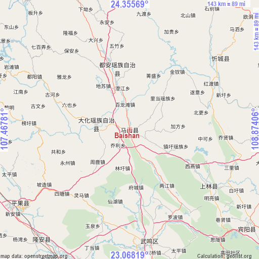
Baishan GPS coordinates[2]
23° 42' 48.708" North, 108° 10' 15.348" East
| Map corner | latitude | longitude |
|---|---|---|
| Upper-left | 24.35569°, | 107.46781° |
| Center: | 23.71353°, | 108.17093° |
| Lower-right: | 23.06819°, | 108.87406° |
| Map W x H: | 143.2×143.2 km | = 89×89mi |
| max Lat: | 53.31946° ⇑91.3% North |
| Baishan: | 23.71353° |
| min Lat: | ⇓8.7% South 18.22056° |
| min Long | Baishan | max Long |
| 75.07348° | 108.17093° | 134.28917° |
| W 20.1%⇐ | ⇒79.9% E |
Elevation
Elevation of Baishan is 174 m = 571 ft, and this is 310.8 m = 1020 ft below average elevation for this country.
| Max E: |
5622 m = 18445 ft | 48.9% |
| Avg. | 484.8 m = 1591 ft | |
| Baishan | 174 m = 571 ft | |
Min E: |
-3 m = -10 ft | 51.1% |
See also: China elevation on elevation.city.
Geographical zone
Baishan is located in North temperate zone (between Tropic of Cancer and the Arctic Circle). Distance of this Northern Tropic circle is 30.8 km =19.1 mi to South.| Distance of | km | miles | from Baishan |
|---|---|---|---|
| North Pole | 7370.4 | 4579.8 | to North |
| Arctic Circle | 4764.5 | 2960.5 | to North |
| Tropic Cancer | 30.8 | 19.1 | to South |
| Equator | 2636.7 | 1638.4 | to South |


Nearby cities:
15 places around Baishan: (largest is in red/bold)
• Anyang
26 km =16.2 mi,  343°
343°
• Bama
106.6 km =66.2 mi,  298°
298°
• Chengxiang
62.4 km =38.8 mi,  169°
169°
• Dafeng
53.5 km =33.2 mi,  125°
125°
• Dahua
20 km =12.4 mi,  287°
287°
• Donglan
122.7 km =76.2 mi,  319°
319°
• Laibin
111.6 km =69.3 mi,  90°
90°
• Long’an Chengxiangzhen
77.4 km =48.1 mi,  223°
223°
• Luxu
84.6 km =52.6 mi, 130°
• Matou
74.2 km =46.1 mi,  237°
237°
• Nanning
100.8 km =62.6 mi, 171°
• Pingma
109.2 km =67.9 mi,  265°
265°
• Pumiao
110.8 km =68.8 mi,  163°
163°
• Xincheng Chengguanzhen
64.1 km =39.8 mi,  49°
49°
• Xinning
119.5 km =74.3 mi,  193°
193°
Sources, notices
• [Note1] Compared only with cities in China existing in our database
• [Src1] Map data: © OpenStreetMap contributors (CC-BY-SA)
• [Src2] Other city data from geonames.org with taken over terms of usage.
• [Src3] Geographical zone / Annual Mean Temperature by Robert A. Rohde @ Wikipedia
