Xincheng Chengguanzhen geodata
Xincheng Chengguanzhen (Guangxi) is a seat of a third-order administrative division; located in China in Asia/Shanghai (GMT+8) time zone. In our database, there are 1268 cities with bigger population. Compared to other cities in China, 90.1% of cities are located further ↑North; 77.9% of cities are located further →East and 51.9% of cities have higher elevation than Xincheng Chengguanzhen. Note1
Current local time in Xincheng Chengguanzhen:
05:54 PM, TuesdayDifference from your time zone: hours


Xincheng Chengguanzhen GPS coordinates[2]
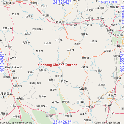
24° 5' 10.068" North, 108° 39' 9.396" East
| Map corner | latitude | longitude |
|---|---|---|
| Upper-left | 24.72642°, | 107.94949° |
| Center: | 24.08613°, | 108.65261° |
| Lower-right: | 23.44263°, | 109.35574° |
| Map W x H: | 142.7×142.7 km | = 88.7×88.7mi |
| max Lat: | 53.31946° ⇑90.1% North |
| Xincheng Chengguanzhen: | 24.08613° |
| min Lat: | ⇓9.9% South 18.22056° |
| min Long | Xincheng Chengg | max Long |
| 75.07348° | 108.65261° | 134.28917° |
| W 22.1%⇐ | ⇒77.9% E |
Elevation
Elevation of Xincheng Chengguanzhen is 150 m = 492 ft, and this is 334.8 m = 1098 ft below average elevation for this country.
| Max E: |
5622 m = 18445 ft | 51.9% |
| Avg. | 484.8 m = 1591 ft | |
| Xincheng Chengguanzhen | 150 m = 492 ft | |
Min E: |
-3 m = -10 ft | 48.1% |
See also: China elevation on elevation.city.
Geographical zone
Xincheng Chengguanzhen is located in North temperate zone (between Tropic of Cancer and the Arctic Circle). Distance of this Northern Tropic circle is 72.2 km =44.9 mi to South.| Distance of | km | miles | from Xincheng Chengguanzhen |
|---|---|---|---|
| North Pole | 7328.9 | 4554 | to North |
| Arctic Circle | 4723 | 2934.7 | to North |
| Tropic Cancer | 72.2 | 44.9 | to South |
| Equator | 2678.1 | 1664.1 | to South |


Nearby cities:
15 places around Xincheng Chengguanzhen: (largest is in red/bold)
• Anyang
58.7 km =36.5 mi,  253°
253°
• Baishan
64.1 km =39.8 mi,  229°
229°
• Chengxiang
109.7 km =68.2 mi,  200°
200°
• Dabu
87.5 km =54.4 mi,  42°
42°
• Dafeng
72.7 km =45.2 mi,  184°
184°
• Dahua
76.6 km =47.6 mi,  242°
242°
• Dongmen
82.4 km =51.2 mi,  17°
17°
• Labu
71.8 km =44.6 mi,  74°
74°
• Laibin
75.8 km =47.1 mi,  124°
124°
• Liuzhou
78.8 km =49 mi, 71°
• Luorong
103.2 km =64.1 mi, 69°
• Luxu
97.4 km =60.5 mi,  170°
170°
• Si’en
92.5 km =57.5 mi,  335°
335°
• Wuxuan
113.8 km =70.7 mi, 116°
• Xiangzhou
103.8 km =64.5 mi,  96°
96°
Sources, notices
• [Note1] Compared only with cities in China existing in our database
• [Src1] Map data: © OpenStreetMap contributors (CC-BY-SA)
• [Src2] Other city data from geonames.org with taken over terms of usage.
• [Src3] Geographical zone / Annual Mean Temperature by Robert A. Rohde @ Wikipedia
