Chuandong geodata
Chuandong (Guizhou) is a populated place; located in China in Asia/Shanghai (GMT+8) time zone. With population of 992 people, there are 1180 cities with bigger population in this country. Compared to other cities in China, 75.2% of cities are located further ↑North; 75.3% of cities are located further →East and 75.3% of cities have lower elevation than Chuandong. Note1


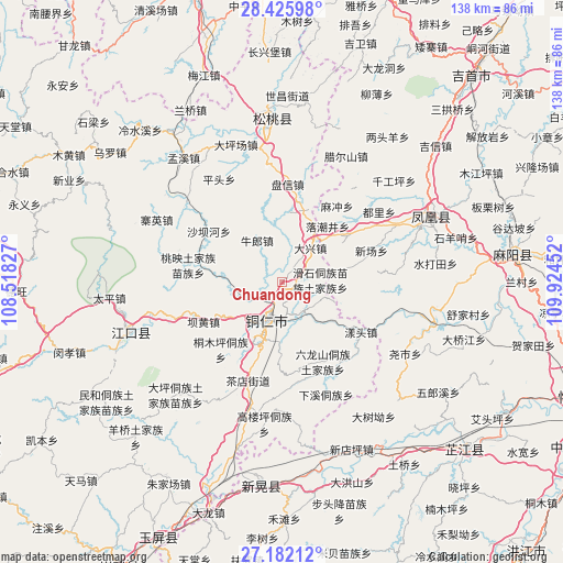
Chuandong GPS coordinates[2]
27° 48' 20.988" North, 109° 13' 17.004" East
| Map corner | latitude | longitude |
|---|---|---|
| Upper-left | 28.42598°, | 108.51827° |
| Center: | 27.80583°, | 109.22139° |
| Lower-right: | 27.18212°, | 109.92452° |
| Map W x H: | 138.3×138.3 km | = 85.9×85.9mi |
| max Lat: | 53.31946° ⇑75.2% North |
| Chuandong: | 27.80583° |
| min Lat: | ⇓24.8% South 18.22056° |
| min Long | Chuandong | max Long |
| 75.07348° | 109.22139° | 134.28917° |
| W 24.7%⇐ | ⇒75.3% E |
Elevation
Elevation of Chuandong is 529 m = 1736 ft, and this is 44.2 m = 145 ft above average elevation for this country.
| Max E: |
5622 m = 18445 ft | 24.7% |
| Chuandong | 529 m 1736 ft | |
| Avg. | 484.8 m = 1591 ft | |
Min E: |
-3 m = -10 ft | 75.3% |
See also: China elevation on elevation.city.
Geographical zone
Chuandong is located in North temperate zone (between Tropic of Cancer and the Arctic Circle). Distance of this Northern Tropic circle is 485.8 km =301.9 mi to South.| Distance of | km | miles | from Chuandong |
|---|---|---|---|
| North Pole | 6915.3 | 4297 | to North |
| Arctic Circle | 4309.5 | 2677.8 | to North |
| Tropic Cancer | 485.8 | 301.9 | to South |
| Equator | 3091.7 | 1921.1 | to South |


Nearby cities:
15 places around Chuandong: (largest is in red/bold)
• Bahuang
22.2 km =13.8 mi,  243°
243°
• Banpan
28.4 km =17.6 mi,  38°
38°
• Bapan
29.7 km =18.5 mi,  249°
249°
• Chadian
26.4 km =16.4 mi,  199°
199°
• Changping
33 km =20.5 mi,  9°
9°
• Chatian
15 km =9.3 mi,  91°
91°
• La’ershan
34.8 km =21.6 mi,  27°
27°
• Mulong
17.2 km =10.7 mi, 240°
• Panxin
24.1 km =15 mi,  3°
3°
• Pingtou
29.6 km =18.4 mi,  329°
329°
• Taipingying
33 km =20.5 mi,  350°
350°
• Tongren
10.5 km =6.5 mi, 199°
• Wanshan
31.5 km =19.6 mi,  182°
182°
• Yangtou
22.9 km =14.2 mi,  124°
124°
• Youyupu
29.5 km =18.3 mi, 196°
Sources, notices
• [Note1] Compared only with cities in China existing in our database
• [Src1] Map data: © OpenStreetMap contributors (CC-BY-SA)
• [Src2] Other city data from geonames.org with taken over terms of usage.
• [Src3] Geographical zone / Annual Mean Temperature by Robert A. Rohde @ Wikipedia
