Chadian geodata
Chadian (Guizhou) is a populated place; located in China in Asia/Shanghai (GMT+8) time zone. With population of 1,089 people, there are 1159 cities with bigger population in this country. Compared to other cities in China, 76.3% of cities are located further ↑North; 75.7% of cities are located further →East and 80% of cities have lower elevation than Chadian. Note1


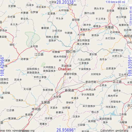
Chadian GPS coordinates[2]
27° 34' 54.984" North, 109° 7' 58.008" East
| Map corner | latitude | longitude |
|---|---|---|
| Upper-left | 28.20338°, | 108.42966° |
| Center: | 27.58194°, | 109.13278° |
| Lower-right: | 26.95696°, | 109.83591° |
| Map W x H: | 138.6×138.6 km | = 86.1×86.1mi |
| max Lat: | 53.31946° ⇑76.3% North |
| Chadian: | 27.58194° |
| min Lat: | ⇓23.7% South 18.22056° |
| min Long | Chadian | max Long |
| 75.07348° | 109.13278° | 134.28917° |
| W 24.3%⇐ | ⇒75.7% E |
Elevation
Elevation of Chadian is 698 m = 2290 ft, and this is 213.2 m = 699 ft above average elevation for this country.
| Max E: |
5622 m = 18445 ft | 20% |
| Chadian | 698 m 2290 ft | |
| Avg. | 484.8 m = 1591 ft | |
Min E: |
-3 m = -10 ft | 80% |
See also: China elevation on elevation.city.
Geographical zone
Chadian is located in North temperate zone (between Tropic of Cancer and the Arctic Circle). Distance of this Northern Tropic circle is 460.9 km =286.4 mi to South.| Distance of | km | miles | from Chadian |
|---|---|---|---|
| North Pole | 6940.2 | 4312.4 | to North |
| Arctic Circle | 4334.3 | 2693.2 | to North |
| Tropic Cancer | 460.9 | 286.4 | to South |
| Equator | 3066.8 | 1905.6 | to South |


Nearby cities:
15 places around Chadian: (largest is in red/bold)
• Bahuang
18.8 km =11.7 mi,  323°
323°
• Bapan
24 km =14.9 mi,  307°
307°
• Bozhou
26.7 km =16.6 mi,  147°
147°
• Chatian
34.1 km =21.2 mi,  44°
44°
• Chuandong
26.4 km =16.4 mi,  19°
19°
• Minhe
35.6 km =22.1 mi,  262°
262°
• Mulong
17.5 km =10.9 mi,  339°
339°
• Tongren
15.9 km =9.9 mi, 18°
• Wanshan
9.7 km =6 mi,  132°
132°
• Xinhuang
23.2 km =14.4 mi,  179°
179°
• Yangliugou
36 km =22.4 mi,  248°
248°
• Yangtou
30.2 km =18.8 mi,  66°
66°
• Yaoshi
39.7 km =24.7 mi,  80°
80°
• Youyupu
3.4 km =2.1 mi, 176°
• Zhujiachang
31.5 km =19.6 mi,  217°
217°
Sources, notices
• [Note1] Compared only with cities in China existing in our database
• [Src1] Map data: © OpenStreetMap contributors (CC-BY-SA)
• [Src2] Other city data from geonames.org with taken over terms of usage.
• [Src3] Geographical zone / Annual Mean Temperature by Robert A. Rohde @ Wikipedia
