Wanshan geodata
Wanshan (Guizhou) is a seat of a third-order administrative division; located in China in Asia/Shanghai (GMT+8) time zone. In our database, there are 1268 cities with bigger population. Compared to other cities in China, 76.5% of cities are located further ↑North; 75.4% of cities are located further →East and 83.2% of cities have lower elevation than Wanshan. Note1


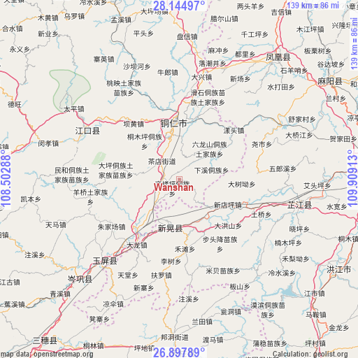
Wanshan GPS coordinates[2]
27° 31' 23.52" North, 109° 12' 21.6" East
| Map corner | latitude | longitude |
|---|---|---|
| Upper-left | 28.14497°, | 108.50288° |
| Center: | 27.5232°, | 109.206° |
| Lower-right: | 26.89789°, | 109.90913° |
| Map W x H: | 138.7×138.7 km | = 86.2×86.2mi |
| max Lat: | 53.31946° ⇑76.5% North |
| Wanshan: | 27.5232° |
| min Lat: | ⇓23.5% South 18.22056° |
| min Long | Wanshan | max Long |
| 75.07348° | 109.206° | 134.28917° |
| W 24.6%⇐ | ⇒75.4% E |
Elevation
Elevation of Wanshan is 865 m = 2838 ft, and this is 380.2 m = 1247 ft above average elevation for this country.
| Max E: |
5622 m = 18445 ft | 16.8% |
| Wanshan | 865 m 2838 ft | |
| Avg. | 484.8 m = 1591 ft | |
Min E: |
-3 m = -10 ft | 83.2% |
See also: China elevation on elevation.city.
Geographical zone
Wanshan is located in North temperate zone (between Tropic of Cancer and the Arctic Circle). Distance of this Northern Tropic circle is 454.4 km =282.4 mi to South.| Distance of | km | miles | from Wanshan |
|---|---|---|---|
| North Pole | 6946.8 | 4316.5 | to North |
| Arctic Circle | 4340.9 | 2697.3 | to North |
| Tropic Cancer | 454.4 | 282.4 | to South |
| Equator | 3060.3 | 1901.6 | to South |


Nearby cities:
15 places around Wanshan: (largest is in red/bold)
• Bahuang
28.4 km =17.6 mi,  319°
319°
• Bapan
33.7 km =20.9 mi,  308°
308°
• Bozhou
17.5 km =10.9 mi,  156°
156°
• Chadian
9.7 km =6 mi, 312°
• Chatian
35.1 km =21.8 mi,  28°
28°
• Chuandong
31.5 km =19.6 mi,  2°
2°
• Mibei
39 km =24.2 mi,  154°
154°
• Mulong
26.5 km =16.5 mi,  329°
329°
• Tongren
21.7 km =13.5 mi,  354°
354°
• Xinhuang
18.1 km =11.2 mi,  203°
203°
• Yangtou
27.6 km =17.1 mi,  47°
47°
• Yaoshi
34.5 km =21.4 mi,  67°
67°
• Youyupu
7.7 km =4.8 mi,  294°
294°
• Zhongzhai
37 km =23 mi,  170°
170°
• Zhujiachang
32.2 km =20 mi,  235°
235°
Sources, notices
• [Note1] Compared only with cities in China existing in our database
• [Src1] Map data: © OpenStreetMap contributors (CC-BY-SA)
• [Src2] Other city data from geonames.org with taken over terms of usage.
• [Src3] Geographical zone / Annual Mean Temperature by Robert A. Rohde @ Wikipedia
