Donglan geodata
Donglan (Guangxi) is a seat of a third-order administrative division; located in China in Asia/Shanghai (GMT+8) time zone. In our database, there are 1268 cities with bigger population. Compared to other cities in China, 88.3% of cities are located further ↑North; 82.5% of cities are located further →East and 65.2% of cities have lower elevation than Donglan. Note1


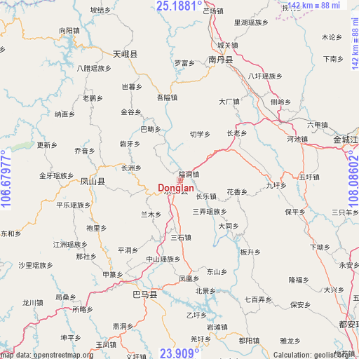
Donglan GPS coordinates[2]
24° 33' 0.648" North, 107° 22' 58.404" East
| Map corner | latitude | longitude |
|---|---|---|
| Upper-left | 25.1881°, | 106.67977° |
| Center: | 24.55018°, | 107.38289° |
| Lower-right: | 23.909°, | 108.08602° |
| Map W x H: | 142.2×142.2 km | = 88.4×88.4mi |
| max Lat: | 53.31946° ⇑88.3% North |
| Donglan: | 24.55018° |
| min Lat: | ⇓11.7% South 18.22056° |
| min Long | Donglan | max Long |
| 75.07348° | 107.38289° | 134.28917° |
| W 17.5%⇐ | ⇒82.5% E |
Elevation
Elevation of Donglan is 330 m = 1083 ft, and this is 154.8 m = 508 ft below average elevation for this country.
| Max E: |
5622 m = 18445 ft | 34.8% |
| Avg. | 484.8 m = 1591 ft | |
| Donglan | 330 m = 1083 ft | |
Min E: |
-3 m = -10 ft | 65.2% |
See also: China elevation on elevation.city.
Geographical zone
Donglan is located in North temperate zone (between Tropic of Cancer and the Arctic Circle). Distance of this Northern Tropic circle is 123.8 km =76.9 mi to South.| Distance of | km | miles | from Donglan |
|---|---|---|---|
| North Pole | 7277.3 | 4521.9 | to North |
| Arctic Circle | 4671.4 | 2902.7 | to North |
| Tropic Cancer | 123.8 | 76.9 | to South |
| Equator | 2729.7 | 1696.2 | to South |


Nearby cities:
15 places around Donglan: (largest is in red/bold)
• Anyang
99.4 km =61.8 mi,  133°
133°
• Baise City
106.4 km =66.1 mi,  227°
227°
• Bama
44.3 km =27.5 mi,  197°
197°
• Chuanshan
91.1 km =56.6 mi,  50°
50°
• Dahua
106.2 km =66 mi,  144°
144°
• Fengcheng
34.5 km =21.4 mi,  273°
273°
• Leli
117.3 km =72.9 mi,  259°
259°
• Liupai
58.4 km =36.3 mi,  338°
338°
• Maolan
116.6 km =72.5 mi,  36°
36°
• Nandan Chengguanzhen
54.1 km =33.6 mi,  18°
18°
• Pingma
105.4 km =65.5 mi, 195°
• Sicheng
82.7 km =51.4 mi, 258°
• Si’en
95.5 km =59.3 mi,  70°
70°
• Tianzhou
98.9 km =61.5 mi,  209°
209°
• Tongle
87.9 km =54.6 mi,  292°
292°
Sources, notices
• [Note1] Compared only with cities in China existing in our database
• [Src1] Map data: © OpenStreetMap contributors (CC-BY-SA)
• [Src2] Other city data from geonames.org with taken over terms of usage.
• [Src3] Geographical zone / Annual Mean Temperature by Robert A. Rohde @ Wikipedia
