Bazhou geodata
Bazhou (Sichuan) is a seat of a third-order administrative division; located in China in Asia/Shanghai (GMT+8) time zone. In our database, there are 1268 cities with bigger population. Compared to other cities in China, 60.3% of cities are located further ↓South; 84.3% of cities are located further →East and 67.4% of cities have lower elevation than Bazhou. Note1


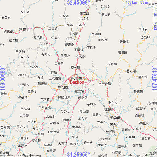
Bazhou GPS coordinates[2]
31° 51' 20.52" North, 106° 46' 19.2" East
| Map corner | latitude | longitude |
|---|---|---|
| Upper-left | 32.45098°, | 106.06888° |
| Center: | 31.8557°, | 106.772° |
| Lower-right: | 31.25655°, | 107.47513° |
| Map W x H: | 132.8×132.8 km | = 82.5×82.5mi |
| max Lat: | 53.31946° ⇑39.7% North |
| Bazhou: | 31.8557° |
| min Lat: | ⇓60.3% South 18.22056° |
| min Long | Bazhou | max Long |
| 75.07348° | 106.772° | 134.28917° |
| W 15.7%⇐ | ⇒84.3% E |
Elevation
Elevation of Bazhou is 366 m = 1201 ft, and this is 118.8 m = 390 ft below average elevation for this country.
| Max E: |
5622 m = 18445 ft | 32.6% |
| Avg. | 484.8 m = 1591 ft | |
| Bazhou | 366 m = 1201 ft | |
Min E: |
-3 m = -10 ft | 67.4% |
See also: China elevation on elevation.city.
Geographical zone
Bazhou is located in North temperate zone (between Tropic of Cancer and the Arctic Circle). Distance of this Northern Tropic circle is 936.1 km =581.7 mi to South.| Distance of | km | miles | from Bazhou |
|---|---|---|---|
| North Pole | 6465 | 4017.2 | to North |
| Arctic Circle | 3859.2 | 2398 | to North |
| Tropic Cancer | 936.1 | 581.7 | to South |
| Equator | 3542 | 2200.9 | to South |


Nearby cities:
15 places around Bazhou: (largest is in red/bold)
• Bazhong
3 km =1.9 mi,  300°
300°
• Changchi
35.9 km =22.3 mi,  342°
342°
• Chixi
33.2 km =20.6 mi,  358°
358°
• Dahe
40.7 km =25.3 mi,  21°
21°
• Fujia
30.1 km =18.7 mi,  345°
345°
• Gaoqiao
27.1 km =16.8 mi,  13°
13°
• Heitan
22.8 km =14.2 mi,  330°
330°
• Heping
29.3 km =18.2 mi,  316°
316°
• Hualong
42.2 km =26.2 mi, 316°
• Huangmao
44 km =27.3 mi,  306°
306°
• Mumen
36.6 km =22.7 mi, 320°
• Pinggang
28.7 km =17.8 mi, 22°
• Shahe
38.9 km =24.2 mi, 353°
• Shima
36.8 km =22.9 mi, 298°
• Xialiang
24.6 km =15.3 mi, 359°
Sources, notices
• [Note1] Compared only with cities in China existing in our database
• [Src1] Map data: © OpenStreetMap contributors (CC-BY-SA)
• [Src2] Other city data from geonames.org with taken over terms of usage.
• [Src3] Geographical zone / Annual Mean Temperature by Robert A. Rohde @ Wikipedia
