Baihe geodata
Baihe (Guangxi) is a populated place; located in China in Asia/Shanghai (GMT+8) time zone. With population of 63,629 people, there are 680 cities with bigger population in this country. Compared to other cities in China, 97.1% of cities are located further ↑North; 83% of cities are located further →East and 56.3% of cities have higher elevation than Baihe. Note1


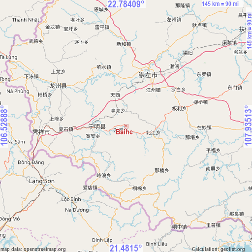
Baihe GPS coordinates[2]
22° 8' 3.48" North, 107° 13' 55.2" East
| Map corner | latitude | longitude |
|---|---|---|
| Upper-left | 22.78409°, | 106.52888° |
| Center: | 22.1343°, | 107.232° |
| Lower-right: | 21.4815°, | 107.93513° |
| Map W x H: | 144.8×144.8 km | = 90×90mi |
| max Lat: | 53.31946° ⇑97.1% North |
| Baihe: | 22.1343° |
| min Lat: | ⇓2.9% South 18.22056° |
| min Long | Baihe | max Long |
| 75.07348° | 107.232° | 134.28917° |
| W 17%⇐ | ⇒83% E |
Elevation
Elevation of Baihe is 122 m = 400 ft, and this is 362.8 m = 1190 ft below average elevation for this country.
| Max E: |
5622 m = 18445 ft | 56.3% |
| Avg. | 484.8 m = 1591 ft | |
| Baihe | 122 m = 400 ft | |
Min E: |
-3 m = -10 ft | 43.7% |
See also: Baihe elevation on elevation.city.
Geographical zone
Baihe is located in North Torrid zone (between Equator and Tropic of Cancer). Distance of this Northern Tropic circle is 144.8 km =90 mi to North.| Distance of | km | miles | from Baihe |
|---|---|---|---|
| North Pole | 7546 | 4688.9 | to North |
| Arctic Circle | 4940.1 | 3069.6 | to North |
| Tropic Cancer | 144.8 | 90 | to North |
| Equator | 2461.1 | 1529.3 | to South |


Nearby cities:
15 places around Baihe: (largest is in red/bold)
• Chengxiang
156.7 km =97.4 mi,  43°
43°
• Chengzhong
23.4 km =14.5 mi,  279°
279°
• Debao Chengguanzhen
154.6 km =96.1 mi,  334°
334°
• Longzhou
54.2 km =33.7 mi,  302°
302°
• Long’an Chengxiangzhen
126.8 km =78.8 mi,  19°
19°
• Matou
139.8 km =86.9 mi,  13°
13°
• Nanning
134.8 km =83.8 mi,  55°
55°
• Pingma
167.7 km =104.2 mi,  355°
355°
• Pumiao
145.9 km =90.7 mi, 61°
• Qinzhou
144.8 km =90 mi,  97°
97°
• Siyang
73.3 km =45.5 mi,  87°
87°
• Taocheng
83.2 km =51.7 mi,  354°
354°
• Tiandeng
111.2 km =69.1 mi, 352°
• Xinjing
147.3 km =91.5 mi,  323°
323°
• Xinning
90.1 km =56 mi,  48°
48°
Sources, notices
• [Note1] Compared only with cities in China existing in our database
• [Src1] Map data: © OpenStreetMap contributors (CC-BY-SA)
• [Src2] Other city data from geonames.org with taken over terms of usage.
• [Src3] Geographical zone / Annual Mean Temperature by Robert A. Rohde @ Wikipedia
