Siyang geodata
Siyang (Guangxi) is a seat of a third-order administrative division; located in China in Asia/Shanghai (GMT+8) time zone. In our database, there are 1268 cities with bigger population. Compared to other cities in China, 97% of cities are located further ↑North; 80.8% of cities are located further →East and 57% of cities have lower elevation than Siyang. Note1


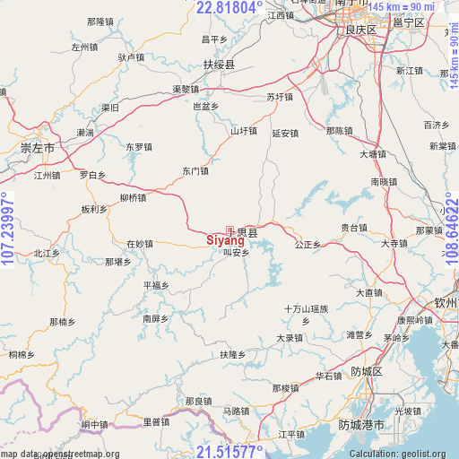
Siyang GPS coordinates[2]
22° 10' 6.276" North, 107° 56' 35.124" East
| Map corner | latitude | longitude |
|---|---|---|
| Upper-left | 22.81804°, | 107.23997° |
| Center: | 22.16841°, | 107.94309° |
| Lower-right: | 21.51577°, | 108.64622° |
| Map W x H: | 144.8×144.8 km | = 90×90mi |
| max Lat: | 53.31946° ⇑97% North |
| Siyang: | 22.16841° |
| min Lat: | ⇓3% South 18.22056° |
| min Long | Siyang | max Long |
| 75.07348° | 107.94309° | 134.28917° |
| W 19.2%⇐ | ⇒80.8% E |
Elevation
Elevation of Siyang is 226 m = 741 ft, and this is 258.8 m = 849 ft below average elevation for this country.
| Max E: |
5622 m = 18445 ft | 43% |
| Avg. | 484.8 m = 1591 ft | |
| Siyang | 226 m = 741 ft | |
Min E: |
-3 m = -10 ft | 57% |
See also: China elevation on elevation.city.
Geographical zone
Siyang is located in North Torrid zone (between Equator and Tropic of Cancer). Distance of this Northern Tropic circle is 141 km =87.6 mi to North.| Distance of | km | miles | from Siyang |
|---|---|---|---|
| North Pole | 7542.2 | 4686.5 | to North |
| Arctic Circle | 4936.3 | 3067.3 | to North |
| Tropic Cancer | 141 | 87.6 | to North |
| Equator | 2464.9 | 1531.6 | to South |


Nearby cities:
15 places around Siyang: (largest is in red/bold)
• Baihe
73.3 km =45.5 mi,  267°
267°
• Beihai
141.6 km =88 mi,  122°
122°
• Chengxiang
115.6 km =71.8 mi,  17°
17°
• Chengzhong
96.4 km =59.9 mi, 269°
• Lianzhou
141.3 km =87.8 mi,  113°
113°
• Lingcheng
141.7 km =88 mi,  78°
78°
• Longzhou
121.4 km =75.4 mi,  282°
282°
• Long’an Chengxiangzhen
119.3 km =74.1 mi,  345°
345°
• Matou
137.8 km =85.6 mi,  343°
343°
• Nanning
81.7 km =50.8 mi,  28°
28°
• Pumiao
85.8 km =53.3 mi,  40°
40°
• Qinzhou
73.7 km =45.8 mi, 107°
• Taocheng
113 km =70.2 mi,  314°
314°
• Tiandeng
137.6 km =85.5 mi,  320°
320°
• Xinning
56.1 km =34.9 mi, 354°
Sources, notices
• [Note1] Compared only with cities in China existing in our database
• [Src1] Map data: © OpenStreetMap contributors (CC-BY-SA)
• [Src2] Other city data from geonames.org with taken over terms of usage.
• [Src3] Geographical zone / Annual Mean Temperature by Robert A. Rohde @ Wikipedia
