Xinning geodata
Xinning (Guangxi) is a seat of a third-order administrative division; located in China in Asia/Shanghai (GMT+8) time zone. In our database, there are 1268 cities with bigger population. Compared to other cities in China, 95.8% of cities are located further ↑North; 80.9% of cities are located further →East and 60.8% of cities have higher elevation than Xinning. Note1


Xinning GPS coordinates[2]
22° 40' 14.88" North, 107° 53' 20.832" East
| Map corner | latitude | longitude |
|---|---|---|
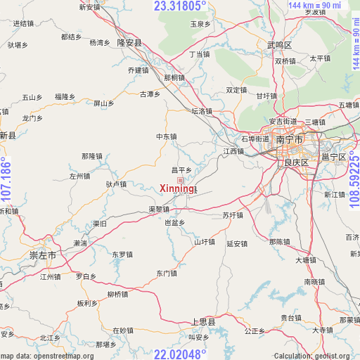
| Upper-left | 23.31805°, | 107.186° |
| Center: | 22.6708°, | 107.88912° |
| Lower-right: | 22.02048°, | 108.59225° |
| Map W x H: | 144.3×144.3 km | = 89.7×89.7mi |
| max Lat: | 53.31946° ⇑95.8% North |
| Xinning: | 22.6708° |
| min Lat: | ⇓4.2% South 18.22056° |
| min Long | Xinning | max Long |
| 75.07348° | 107.88912° | 134.28917° |
| W 19.1%⇐ | ⇒80.9% E |
Elevation
Elevation of Xinning is 94 m = 308 ft, and this is 390.8 m = 1282 ft below average elevation for this country.
| Max E: |
5622 m = 18445 ft | 60.8% |
| Avg. | 484.8 m = 1591 ft | |
| Xinning | 94 m = 308 ft | |
Min E: |
-3 m = -10 ft | 39.2% |
See also: China elevation on elevation.city.
Geographical zone
Xinning is located in North Torrid zone (between Equator and Tropic of Cancer). Distance of this Northern Tropic circle is 85.2 km =52.9 mi to North.| Distance of | km | miles | from Xinning |
|---|---|---|---|
| North Pole | 7486.3 | 4651.8 | to North |
| Arctic Circle | 4880.4 | 3032.5 | to North |
| Tropic Cancer | 85.2 | 52.9 | to North |
| Equator | 2520.8 | 1566.4 | to South |


Nearby cities:
15 places around Xinning: (largest is in red/bold)
• Baihe
90.1 km =56 mi,  228°
228°
• Baishan
119.5 km =74.3 mi,  13°
13°
• Chengxiang
67.5 km =41.9 mi,  36°
36°
• Chengzhong
106.5 km =66.2 mi,  238°
238°
• Dafeng
111.7 km =69.4 mi, 40°
• Longzhou
116.9 km =72.6 mi,  255°
255°
• Long’an Chengxiangzhen
64.4 km =40 mi,  337°
337°
• Luxu
111.8 km =69.5 mi,  56°
56°
• Matou
83.4 km =51.8 mi, 335°
• Nanning
46.7 km =29 mi,  69°
69°
• Pumiao
61.5 km =38.2 mi,  80°
80°
• Qinzhou
108.5 km =67.4 mi,  135°
135°
• Siyang
56.1 km =34.9 mi,  174°
174°
• Taocheng
78.6 km =48.8 mi,  287°
287°
• Tiandeng
95.9 km =59.6 mi,  301°
301°
Sources, notices
• [Note1] Compared only with cities in China existing in our database
• [Src1] Map data: © OpenStreetMap contributors (CC-BY-SA)
• [Src2] Other city data from geonames.org with taken over terms of usage.
• [Src3] Geographical zone / Annual Mean Temperature by Robert A. Rohde @ Wikipedia
