Beiyingzi geodata
Beiyingzi (Liaoning) is a seat of a fourth-order administrative division; located in China in Asia/Shanghai (GMT+8) time zone. In our database, there are 1268 cities with bigger population. Compared to other cities in China, 88.6% of cities are located further ↓South; 76.7% of cities are located further ←West and 65.5% of cities have lower elevation than Beiyingzi. Note1


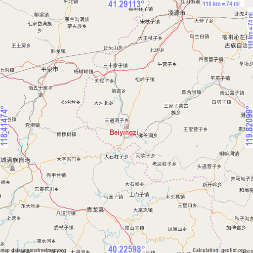
Beiyingzi GPS coordinates[2]
40° 45' 38.484" North, 119° 7' 4.296" East
| Map corner | latitude | longitude |
|---|---|---|
| Upper-left | 41.29113°, | 118.41474° |
| Center: | 40.76069°, | 119.11786° |
| Lower-right: | 40.22598°, | 119.82099° |
| Map W x H: | 118.4×118.4 km | = 73.6×73.6mi |
| max Lat: | 53.31946° ⇑11.4% North |
| Beiyingzi: | 40.76069° |
| min Lat: | ⇓88.6% South 18.22056° |
| min Long | Beiyingzi | max Long |
| 75.07348° | 119.11786° | 134.28917° |
| W 76.7%⇐ | ⇒23.3% E |
Elevation
Elevation of Beiyingzi is 334 m = 1096 ft, and this is 150.8 m = 495 ft below average elevation for this country.
| Max E: |
5622 m = 18445 ft | 34.5% |
| Avg. | 484.8 m = 1591 ft | |
| Beiyingzi | 334 m = 1096 ft | |
Min E: |
-3 m = -10 ft | 65.5% |
See also: China elevation on elevation.city.
Geographical zone
Beiyingzi is located in North temperate zone (between Tropic of Cancer and the Arctic Circle). Distance of this Northern Tropic circle is 1926.2 km =1196.9 mi to South.| Distance of | km | miles | from Beiyingzi |
|---|---|---|---|
| North Pole | 5474.9 | 3401.9 | to North |
| Arctic Circle | 2869 | 1782.7 | to North |
| Tropic Cancer | 1926.2 | 1196.9 | to South |
| Equator | 4532.2 | 2816.2 | to South |


Nearby cities:
15 places around Beiyingzi: (largest is in red/bold)
• Dadianzi
82.8 km =51.4 mi,  135°
135°
• Dongshangen
69.9 km =43.4 mi,  127°
127°
• Guangyudian
79.5 km =49.4 mi,  113°
113°
• Jiabeiyan
70.6 km =43.9 mi, 132°
• Kuanbang
89.2 km =55.4 mi, 108°
• Kuancheng
56.3 km =35 mi,  252°
252°
• Lingyuan
58.4 km =36.3 mi,  24°
24°
• Miaodong
63.7 km =39.6 mi, 24°
• Mingshui
78.7 km =48.9 mi,  124°
124°
• Nanjie
29.1 km =18.1 mi,  349°
349°
• Pingquan
45.3 km =28.1 mi,  306°
306°
• Qinglong
42.1 km =26.2 mi,  200°
200°
• Songling
88.6 km =55.1 mi,  234°
234°
• Tianyi
91.4 km =56.8 mi,  11°
11°
• Yebaishou
83.3 km =51.8 mi,  31°
31°
Sources, notices
• [Note1] Compared only with cities in China existing in our database
• [Src1] Map data: © OpenStreetMap contributors (CC-BY-SA)
• [Src2] Other city data from geonames.org with taken over terms of usage.
• [Src3] Geographical zone / Annual Mean Temperature by Robert A. Rohde @ Wikipedia
