Yuquan geodata
Yuquan (Shanxi) is a seat of a third-order administrative division; located in China in Asia/Shanghai (GMT+8) time zone. In our database, there are 1268 cities with bigger population. Compared to other cities in China, 87.9% of cities are located further ↓South; 51.5% of cities are located further →East and 86.3% of cities have lower elevation than Yuquan. Note1


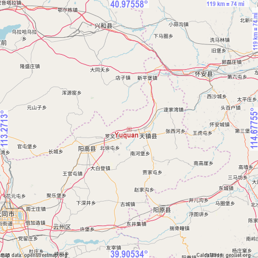
Yuquan GPS coordinates[2]
40° 26' 33.324" North, 113° 58' 27.912" East
| Map corner | latitude | longitude |
|---|---|---|
| Upper-left | 40.97558°, | 113.2713° |
| Center: | 40.44259°, | 113.97442° |
| Lower-right: | 39.90534°, | 114.67755° |
| Map W x H: | 119×119 km | = 73.9×73.9mi |
| max Lat: | 53.31946° ⇑12.1% North |
| Yuquan: | 40.44259° |
| min Lat: | ⇓87.9% South 18.22056° |
| min Long | Yuquan | max Long |
| 75.07348° | 113.97442° | 134.28917° |
| W 48.5%⇐ | ⇒51.5% E |
Elevation
Elevation of Yuquan is 1063 m = 3488 ft, and this is 578.2 m = 1897 ft above average elevation for this country.
| Max E: |
5622 m = 18445 ft | 13.7% |
| Yuquan | 1063 m 3488 ft | |
| Avg. | 484.8 m = 1591 ft | |
Min E: |
-3 m = -10 ft | 86.3% |
See also: China elevation on elevation.city.
Geographical zone
Yuquan is located in North temperate zone (between Tropic of Cancer and the Arctic Circle). Distance of this Northern Tropic circle is 1890.9 km =1175 mi to South.| Distance of | km | miles | from Yuquan |
|---|---|---|---|
| North Pole | 5510.3 | 3423.9 | to North |
| Arctic Circle | 2904.4 | 1804.7 | to North |
| Tropic Cancer | 1890.9 | 1175 | to South |
| Equator | 4496.8 | 2794.2 | to South |


Nearby cities:
15 places around Yuquan: (largest is in red/bold)
• Aoshi
52.9 km =32.9 mi,  180°
180°
• Beichengqu
69.5 km =43.2 mi,  269°
269°
• Beijiazao
60.9 km =37.8 mi,  224°
224°
• Chaigoubu
44.6 km =27.7 mi,  55°
55°
• Dangliuzhuang
68.9 km =42.8 mi, 222°
• Fengyu
65.5 km =40.7 mi,  208°
208°
• Guayuan
54.3 km =33.7 mi, 210°
• Jule
45.8 km =28.5 mi,  227°
227°
• Longquan
27.5 km =17.1 mi,  251°
251°
• Xicheng
40.1 km =24.9 mi,  157°
157°
• Xinghe Chengguanzhen
48.7 km =30.3 mi,  350°
350°
• Xiping
54.7 km =34 mi, 215°
• Xubu
50.1 km =31.1 mi,  202°
202°
• Youzai
55.2 km =34.3 mi,  187°
187°
• Zhoushizhuang
56.5 km =35.1 mi, 229°
Sources, notices
• [Note1] Compared only with cities in China existing in our database
• [Src1] Map data: © OpenStreetMap contributors (CC-BY-SA)
• [Src2] Other city data from geonames.org with taken over terms of usage.
• [Src3] Geographical zone / Annual Mean Temperature by Robert A. Rohde @ Wikipedia
