Shuangcheng geodata
Shuangcheng (Heilongjiang) is a populated place; located in China in Asia/Shanghai (GMT+8) time zone. With population of 130,710 people, there are 335 cities with bigger population in this country. Compared to other cities in China, 94.2% of cities are located further ↓South; 95.9% of cities are located further ←West and 50.2% of cities have higher elevation than Shuangcheng. Note1


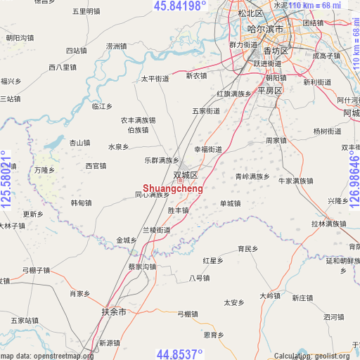
Shuangcheng GPS coordinates[2]
45° 21' 0" North, 126° 16' 59.988" East
| Map corner | latitude | longitude |
|---|---|---|
| Upper-left | 45.84198°, | 125.58021° |
| Center: | 45.35°, | 126.28333° |
| Lower-right: | 44.8537°, | 126.98646° |
| Map W x H: | 109.9×109.9 km | = 68.3×68.3mi |
| max Lat: | 53.31946° ⇑5.8% North |
| Shuangcheng: | 45.35° |
| min Lat: | ⇓94.2% South 18.22056° |
| min Long | Shuangcheng | max Long |
| 75.07348° | 126.28333° | 134.28917° |
| W 95.9%⇐ | ⇒4.1% E |
Elevation
Elevation of Shuangcheng is 163 m = 535 ft, and this is 321.8 m = 1056 ft below average elevation for this country.
| Max E: |
5622 m = 18445 ft | 50.2% |
| Avg. | 484.8 m = 1591 ft | |
| Shuangcheng | 163 m = 535 ft | |
Min E: |
-3 m = -10 ft | 49.8% |
See also: Shuangcheng elevation on elevation.city.
Geographical zone
Shuangcheng is located in North temperate zone (between Tropic of Cancer and the Arctic Circle). Distance of this North polar circle is 2358.7 km =1465.6 mi to North.| Distance of | km | miles | from Shuangcheng |
|---|---|---|---|
| North Pole | 4964.6 | 3084.9 | to North |
| Arctic Circle | 2358.7 | 1465.6 | to North |
| Tropic Cancer | 2436.5 | 1514 | to South |
| Equator | 5042.4 | 3133.2 | to South |


Nearby cities:
15 places around Shuangcheng: (largest is in red/bold)
• Acheng
58.3 km =36.2 mi,  68°
68°
• Ashihe
57.7 km =35.9 mi, 69°
• Bajiazi
60.8 km =37.8 mi,  102°
102°
• Beiyinhe
59.7 km =37.1 mi,  109°
109°
• Harbin
52.9 km =32.9 mi,  32°
32°
• Jiaojie
62.9 km =39.1 mi,  90°
90°
• Qingshan
56.3 km =35 mi,  121°
121°
• Sanchahe
47.9 km =29.8 mi,  206°
206°
• Sheli
55.6 km =34.5 mi,  64°
64°
• Shuangfeng
54.3 km =33.7 mi,  79°
79°
• Xinglong
48.5 km =30.1 mi, 96°
• Yagou
63.8 km =39.6 mi, 76°
• Yanhe
56.2 km =34.9 mi, 117°
• Yingchengzi
56.4 km =35 mi, 111°
• Yushu
64.2 km =39.9 mi,  162°
162°
Sources, notices
• [Note1] Compared only with cities in China existing in our database
• [Src1] Map data: © OpenStreetMap contributors (CC-BY-SA)
• [Src2] Other city data from geonames.org with taken over terms of usage.
• [Src3] Geographical zone / Annual Mean Temperature by Robert A. Rohde @ Wikipedia
