Sanka geodata
Sanka (Heilongjiang) is a seat of a fourth-order administrative division; located in China in Asia/Shanghai (GMT+8) time zone. In our database, there are 1268 cities with bigger population. Compared to other cities in China, 99.8% of cities are located further ↓South; 96.5% of cities are located further ←West and 51.5% of cities have higher elevation than Sanka. Note1


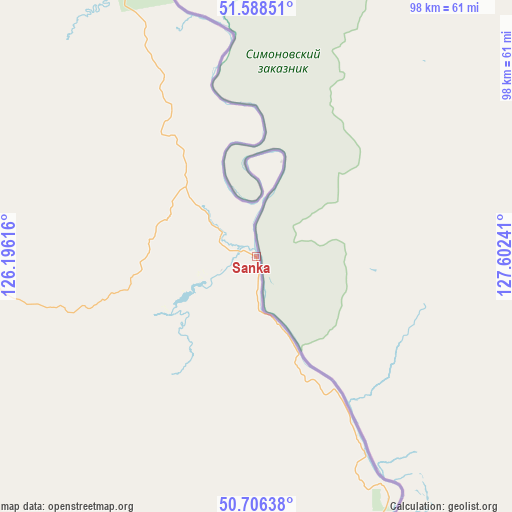
Sanka GPS coordinates[2]
51° 8' 58.38" North, 126° 53' 57.408" East
| Map corner | latitude | longitude |
|---|---|---|
| Upper-left | 51.58851°, | 126.19616° |
| Center: | 51.14955°, | 126.89928° |
| Lower-right: | 50.70638°, | 127.60241° |
| Map W x H: | 98.1×98.1 km | = 61×61mi |
| max Lat: | 53.31946° ⇑0.2% North |
| Sanka: | 51.14955° |
| min Lat: | ⇓99.8% South 18.22056° |
| min Long | Sanka | max Long |
| 75.07348° | 126.89928° | 134.28917° |
| W 96.5%⇐ | ⇒3.5% E |
Elevation
Elevation of Sanka is 153 m = 502 ft, and this is 331.8 m = 1089 ft below average elevation for this country.
| Max E: |
5622 m = 18445 ft | 51.5% |
| Avg. | 484.8 m = 1591 ft | |
| Sanka | 153 m = 502 ft | |
Min E: |
-3 m = -10 ft | 48.5% |
See also: China elevation on elevation.city.
Geographical zone
Sanka is located in North temperate zone (between Tropic of Cancer and the Arctic Circle). Distance of this North polar circle is 1713.9 km =1065 mi to North.| Distance of | km | miles | from Sanka |
|---|---|---|---|
| North Pole | 4319.8 | 2684.2 | to North |
| Arctic Circle | 1713.9 | 1065 | to North |
| Tropic Cancer | 3081.4 | 1914.7 | to South |
| Equator | 5687.3 | 3533.9 | to South |


Nearby cities:
15 places around Sanka: (largest is in red/bold)
• Aihui
136.4 km =84.8 mi,  162°
162°
• Beijiang
57.7 km =35.9 mi,  257°
257°
• Handaqi
123.3 km =76.6 mi,  203°
203°
• Hanjiayuan
129.7 km =80.6 mi,  321°
321°
• Heihe
108.9 km =67.7 mi, 157°
• Jinshan
114 km =70.8 mi,  346°
346°
• Khuma
65.7 km =40.8 mi,  343°
343°
• Shangmachang
91.6 km =56.9 mi, 160°
• Sijiazi
116.3 km =72.3 mi, 158°
• Xifengshan
65.2 km =40.5 mi,  175°
175°
• Xinfu
109.6 km =68.1 mi, 157°
• Xinghua
125 km =77.7 mi,  330°
330°
• Xing’an
108.7 km =67.5 mi, 157°
• Xinsheng Elunchunzu
71.5 km =44.4 mi,  186°
186°
• Zhangdiyingzi
73.5 km =45.7 mi, 155°
Sources, notices
• [Note1] Compared only with cities in China existing in our database
• [Src1] Map data: © OpenStreetMap contributors (CC-BY-SA)
• [Src2] Other city data from geonames.org with taken over terms of usage.
• [Src3] Geographical zone / Annual Mean Temperature by Robert A. Rohde @ Wikipedia
