Kangbao geodata
Kangbao (Hebei) is a seat of a third-order administrative division; located in China in Asia/Shanghai (GMT+8) time zone. In our database, there are 1268 cities with bigger population. Compared to other cities in China, 90.8% of cities are located further ↓South; 52.1% of cities are located further ←West and 90.6% of cities have lower elevation than Kangbao. Note1


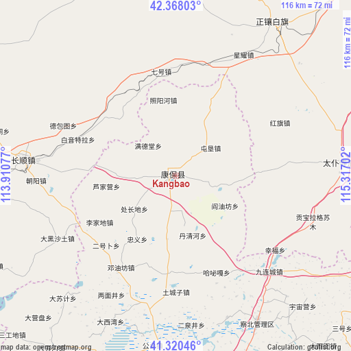
Kangbao GPS coordinates[2]
41° 50' 47.004" North, 114° 36' 50.004" East
| Map corner | latitude | longitude |
|---|---|---|
| Upper-left | 42.36803°, | 113.91077° |
| Center: | 41.84639°, | 114.61389° |
| Lower-right: | 41.32046°, | 115.31702° |
| Map W x H: | 116.5×116.5 km | = 72.4×72.4mi |
| max Lat: | 53.31946° ⇑9.2% North |
| Kangbao: | 41.84639° |
| min Lat: | ⇓90.8% South 18.22056° |
| min Long | Kangbao | max Long |
| 75.07348° | 114.61389° | 134.28917° |
| W 52.1%⇐ | ⇒47.9% E |
Elevation
Elevation of Kangbao is 1413 m = 4636 ft, and this is 928.2 m = 3045 ft above average elevation for this country.
| Max E: |
5622 m = 18445 ft | 9.4% |
| Kangbao | 1413 m 4636 ft | |
| Avg. | 484.8 m = 1591 ft | |
Min E: |
-3 m = -10 ft | 90.6% |
See also: China elevation on elevation.city.
Geographical zone
Kangbao is located in North temperate zone (between Tropic of Cancer and the Arctic Circle). Distance of this Northern Tropic circle is 2047 km =1271.9 mi to South.| Distance of | km | miles | from Kangbao |
|---|---|---|---|
| North Pole | 5354.2 | 3326.9 | to North |
| Arctic Circle | 2748.3 | 1707.7 | to North |
| Tropic Cancer | 2047 | 1271.9 | to South |
| Equator | 4652.9 | 2891.2 | to South |


Nearby cities:
15 places around Kangbao: (largest is in red/bold)
• Baochang
55.2 km =34.3 mi,  85°
85°
• Changshun
51.7 km =32.1 mi,  275°
275°
• Hayan Hudong
117.7 km =73.1 mi,  247°
247°
• Kongjiazhuang
122 km =75.8 mi,  175°
175°
• Ming’antu
59.6 km =37 mi,  31°
31°
• Nanhaoqian
102.3 km =63.6 mi,  212°
212°
• Pingdingbu
92.1 km =57.2 mi,  102°
102°
• Qitai
95.5 km =59.3 mi, 249°
• Shimenkou
121.2 km =75.3 mi,  244°
244°
• Tumu’ertai
121.8 km =75.7 mi,  269°
269°
• Wulan Hada
120.9 km =75.1 mi,  258°
258°
• Xin Bulag
77.5 km =48.2 mi,  304°
304°
• Xiwanzi
111.7 km =69.4 mi,  150°
150°
• Zhangbei
77.5 km =48.2 mi,  174°
174°
• Zhangjiakou
117.3 km =72.9 mi, 169°
Sources, notices
• [Note1] Compared only with cities in China existing in our database
• [Src1] Map data: © OpenStreetMap contributors (CC-BY-SA)
• [Src2] Other city data from geonames.org with taken over terms of usage.
• [Src3] Geographical zone / Annual Mean Temperature by Robert A. Rohde @ Wikipedia
