Nanhaoqian geodata
Nanhaoqian (Hebei) is a seat of a third-order administrative division; located in China in Asia/Shanghai (GMT+8) time zone. In our database, there are 1268 cities with bigger population. Compared to other cities in China, 89.3% of cities are located further ↓South; 51.6% of cities are located further →East and 89.9% of cities have lower elevation than Nanhaoqian. Note1


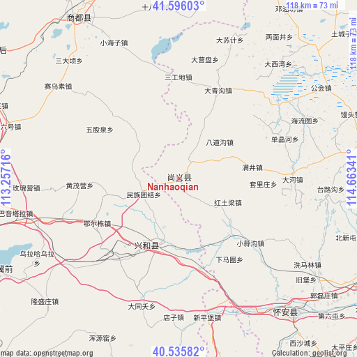
Nanhaoqian GPS coordinates[2]
41° 4' 5.016" North, 113° 57' 37.008" East
| Map corner | latitude | longitude |
|---|---|---|
| Upper-left | 41.59603°, | 113.25716° |
| Center: | 41.06806°, | 113.96028° |
| Lower-right: | 40.53582°, | 114.66341° |
| Map W x H: | 117.9×117.9 km | = 73.3×73.3mi |
| max Lat: | 53.31946° ⇑10.7% North |
| Nanhaoqian: | 41.06806° |
| min Lat: | ⇓89.3% South 18.22056° |
| min Long | Nanhaoqian | max Long |
| 75.07348° | 113.96028° | 134.28917° |
| W 48.4%⇐ | ⇒51.6% E |
Elevation
Elevation of Nanhaoqian is 1348 m = 4423 ft, and this is 863.2 m = 2832 ft above average elevation for this country.
| Max E: |
5622 m = 18445 ft | 10.1% |
| Nanhaoqian | 1348 m 4423 ft | |
| Avg. | 484.8 m = 1591 ft | |
Min E: |
-3 m = -10 ft | 89.9% |
See also: China elevation on elevation.city.
Geographical zone
Nanhaoqian is located in North temperate zone (between Tropic of Cancer and the Arctic Circle). Distance of this Northern Tropic circle is 1960.4 km =1218.1 mi to South.| Distance of | km | miles | from Nanhaoqian |
|---|---|---|---|
| North Pole | 5440.7 | 3380.7 | to North |
| Arctic Circle | 2834.8 | 1761.5 | to North |
| Tropic Cancer | 1960.4 | 1218.1 | to South |
| Equator | 4566.3 | 2837.4 | to South |


Nearby cities:
15 places around Nanhaoqian: (largest is in red/bold)
• Baiyin Chagan
77.8 km =48.3 mi,  303°
303°
• Benhong
64.9 km =40.3 mi,  292°
292°
• Chaigoubu
58.5 km =36.4 mi,  139°
139°
• Daliuhao
58.8 km =36.5 mi, 287°
• Hayan Hudong
69.1 km =42.9 mi,  307°
307°
• Jining
71.8 km =44.6 mi,  266°
266°
• Kongjiazhuang
73.3 km =45.5 mi,  118°
118°
• Longquan
82.1 km =51 mi,  197°
197°
• Qitai
64.3 km =40 mi,  326°
326°
• Shimenkou
64.7 km =40.2 mi, 301°
• Shiyaogou
78.4 km =48.7 mi, 288°
• Togrog Ul
70.7 km =43.9 mi,  243°
243°
• Xinghe Chengguanzhen
22.3 km =13.9 mi, 196°
• Yuquan
69.6 km =43.2 mi,  179°
179°
• Zhangbei
63.3 km =39.3 mi,  81°
81°
Sources, notices
• [Note1] Compared only with cities in China existing in our database
• [Src1] Map data: © OpenStreetMap contributors (CC-BY-SA)
• [Src2] Other city data from geonames.org with taken over terms of usage.
• [Src3] Geographical zone / Annual Mean Temperature by Robert A. Rohde @ Wikipedia
