Kulun geodata
Kulun (Inner Mongolia) is a seat of a third-order administrative division; located in China in Asia/Shanghai (GMT+8) time zone. In our database, there are 1268 cities with bigger population. Compared to other cities in China, 91.6% of cities are located further ↓South; 90.7% of cities are located further ←West and 60.5% of cities have lower elevation than Kulun. Note1


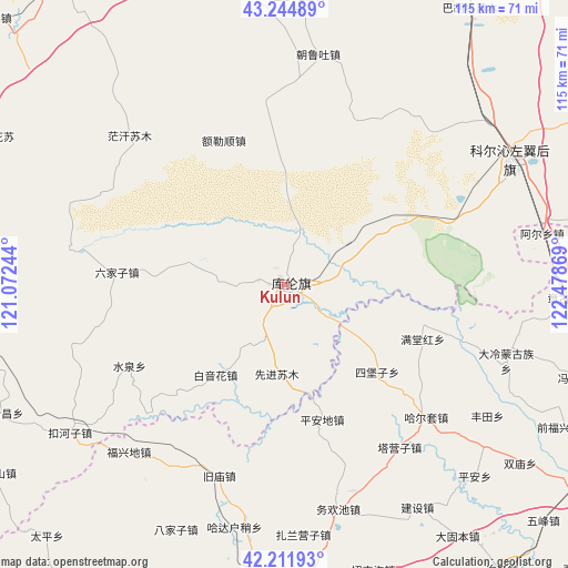
Kulun GPS coordinates[2]
42° 43' 50.016" North, 121° 46' 32.016" East
| Map corner | latitude | longitude |
|---|---|---|
| Upper-left | 43.24489°, | 121.07244° |
| Center: | 42.73056°, | 121.77556° |
| Lower-right: | 42.21193°, | 122.47869° |
| Map W x H: | 114.9×114.9 km | = 71.4×71.4mi |
| max Lat: | 53.31946° ⇑8.4% North |
| Kulun: | 42.73056° |
| min Lat: | ⇓91.6% South 18.22056° |
| min Long | Kulun | max Long |
| 75.07348° | 121.77556° | 134.28917° |
| W 90.7%⇐ | ⇒9.3% E |
Elevation
Elevation of Kulun is 266 m = 873 ft, and this is 218.8 m = 718 ft below average elevation for this country.
| Max E: |
5622 m = 18445 ft | 39.5% |
| Avg. | 484.8 m = 1591 ft | |
| Kulun | 266 m = 873 ft | |
Min E: |
-3 m = -10 ft | 60.5% |
See also: China elevation on elevation.city.
Geographical zone
Kulun is located in North temperate zone (between Tropic of Cancer and the Arctic Circle). Distance of this Northern Tropic circle is 2145.3 km =1333 mi to South.| Distance of | km | miles | from Kulun |
|---|---|---|---|
| North Pole | 5255.9 | 3265.9 | to North |
| Arctic Circle | 2650 | 1646.6 | to North |
| Tropic Cancer | 2145.3 | 1333 | to South |
| Equator | 4751.2 | 2952.3 | to South |


Nearby cities:
15 places around Kulun: (largest is in red/bold)
• Baga Borihe
101.5 km =63.1 mi,  282°
282°
• Daqin Tal
91.5 km =56.9 mi, 280°
• Fuxin
80.1 km =49.8 mi,  186°
186°
• Heichengzi
92.9 km =57.7 mi,  224°
224°
• Huanghuatala
82 km =51 mi,  264°
264°
• Kailu
105.7 km =65.7 mi,  333°
333°
• Liushutun
98.1 km =61 mi,  96°
96°
• Taijiying
90.7 km =56.4 mi,  226°
226°
• Tongliao
105.8 km =65.7 mi,  22°
22°
• Tuchengzi
90.5 km =56.2 mi,  241°
241°
• Xar Holoi
85.6 km =53.2 mi, 257°
• Xiawa
102.3 km =63.6 mi, 260°
• Xizhahaqi
91 km =56.5 mi,  93°
93°
• Yilongyong
92.7 km =57.6 mi, 263°
• Zhangqiang
99.5 km =61.8 mi, 93°
Sources, notices
• [Note1] Compared only with cities in China existing in our database
• [Src1] Map data: © OpenStreetMap contributors (CC-BY-SA)
• [Src2] Other city data from geonames.org with taken over terms of usage.
• [Src3] Geographical zone / Annual Mean Temperature by Robert A. Rohde @ Wikipedia
