Tongliao geodata
Tongliao (Inner Mongolia) is a seat of a second-order administrative division; located in China in Asia/Shanghai (GMT+8) time zone. With population of 261,110 people, there are 191 cities with bigger population in this country. Compared to other cities in China, 92.4% of cities are located further ↓South; 91.7% of cities are located further ←West and 52.1% of cities have lower elevation than Tongliao. Note1


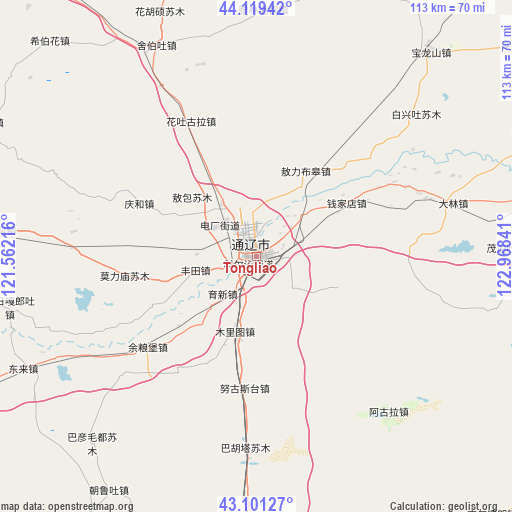
Tongliao GPS coordinates[2]
43° 36' 45" North, 122° 15' 55.008" East
| Map corner | latitude | longitude |
|---|---|---|
| Upper-left | 44.11942°, | 121.56216° |
| Center: | 43.6125°, | 122.26528° |
| Lower-right: | 43.10127°, | 122.96841° |
| Map W x H: | 113.2×113.2 km | = 70.3×70.3mi |
| max Lat: | 53.31946° ⇑7.6% North |
| Tongliao: | 43.6125° |
| min Lat: | ⇓92.4% South 18.22056° |
| min Long | Tongliao | max Long |
| 75.07348° | 122.26528° | 134.28917° |
| W 91.7%⇐ | ⇒8.3% E |
Elevation
Elevation of Tongliao is 182 m = 597 ft, and this is 302.8 m = 993 ft below average elevation for this country.
| Max E: |
5622 m = 18445 ft | 47.9% |
| Avg. | 484.8 m = 1591 ft | |
| Tongliao | 182 m = 597 ft | |
Min E: |
-3 m = -10 ft | 52.1% |
See also: Tongliao elevation on elevation.city.
Geographical zone
Tongliao is located in North temperate zone (between Tropic of Cancer and the Arctic Circle). Distance of this Northern Tropic circle is 2243.3 km =1393.9 mi to South.| Distance of | km | miles | from Tongliao |
|---|---|---|---|
| North Pole | 5157.8 | 3204.9 | to North |
| Arctic Circle | 2551.9 | 1585.7 | to North |
| Tropic Cancer | 2243.3 | 1393.9 | to South |
| Equator | 4849.3 | 3013.2 | to South |


Nearby cities:
15 places around Tongliao: (largest is in red/bold)
• Baokang
100.6 km =62.5 mi,  55°
55°
• Bor Ondor
73.5 km =45.7 mi,  8°
8°
• Dolod
118.2 km =73.4 mi,  326°
326°
• Erniusuokou
118.6 km =73.7 mi,  142°
142°
• Haizhouwobao
116.7 km =72.5 mi,  129°
129°
• Jurh
81 km =50.3 mi,  323°
323°
• Kailu
85.8 km =53.3 mi,  267°
267°
• Kulun
105.8 km =65.7 mi,  202°
202°
• Liushutun
123.5 km =76.7 mi,  152°
152°
• Xiaochengzi
110.6 km =68.7 mi, 136°
• Xinfa
108.9 km =67.7 mi, 7°
• Xinhua
118.1 km =73.4 mi,  23°
23°
• Xizhahaqi
115.7 km =71.9 mi, 154°
• Zhangqiang
118.9 km =73.9 mi, 150°
• Zhengjiatun
100.7 km =62.6 mi,  96°
96°
Sources, notices
• [Note1] Compared only with cities in China existing in our database
• [Src1] Map data: © OpenStreetMap contributors (CC-BY-SA)
• [Src2] Other city data from geonames.org with taken over terms of usage.
• [Src3] Geographical zone / Annual Mean Temperature by Robert A. Rohde @ Wikipedia
