Fengcheng geodata
Fengcheng (Liaoning) is a populated place; located in China in Asia/Shanghai (GMT+8) time zone. With population of 120,514 people, there are 366 cities with bigger population in this country. Compared to other cities in China, 88% of cities are located further ↓South; 93.9% of cities are located further ←West and 66.8% of cities have higher elevation than Fengcheng. Note1


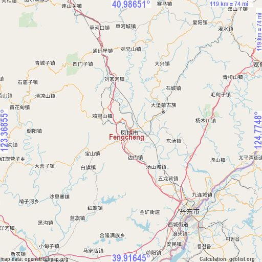
Fengcheng GPS coordinates[2]
40° 27' 12.996" North, 124° 4' 18.012" East
| Map corner | latitude | longitude |
|---|---|---|
| Upper-left | 40.98651°, | 123.36855° |
| Center: | 40.45361°, | 124.07167° |
| Lower-right: | 39.91645°, | 124.7748° |
| Map W x H: | 119×119 km | = 73.9×73.9mi |
| max Lat: | 53.31946° ⇑12% North |
| Fengcheng: | 40.45361° |
| min Lat: | ⇓88% South 18.22056° |
| min Long | Fengcheng | max Long |
| 75.07348° | 124.07167° | 134.28917° |
| W 93.9%⇐ | ⇒6.1% E |
Elevation
Elevation of Fengcheng is 65 m = 213 ft, and this is 419.8 m = 1377 ft below average elevation for this country.
| Max E: |
5622 m = 18445 ft | 66.8% |
| Avg. | 484.8 m = 1591 ft | |
| Fengcheng | 65 m = 213 ft | |
Min E: |
-3 m = -10 ft | 33.2% |
See also: Fengcheng elevation on elevation.city.
Geographical zone
Fengcheng is located in North temperate zone (between Tropic of Cancer and the Arctic Circle). Distance of this Northern Tropic circle is 1892.1 km =1175.7 mi to South.| Distance of | km | miles | from Fengcheng |
|---|---|---|---|
| North Pole | 5509 | 3423.1 | to North |
| Arctic Circle | 2903.2 | 1804 | to North |
| Tropic Cancer | 1892.1 | 1175.7 | to South |
| Equator | 4498 | 2794.9 | to South |


Nearby cities:
15 places around Fengcheng: (largest is in red/bold)
• Baiqi
25.2 km =15.7 mi,  230°
230°
• Baoshan
20.4 km =12.7 mi,  240°
240°
• Caohekou
49.4 km =30.7 mi,  343°
343°
• Chaoyang
44.1 km =27.4 mi,  270°
270°
• Dandong
45.3 km =28.1 mi,  142°
142°
• Dayingzi
42.3 km =26.3 mi,  248°
248°
• Hongqi
38.5 km =23.9 mi,  205°
205°
• Jiguanshan
15.2 km =9.4 mi,  299°
299°
• Lanqi
46.1 km =28.6 mi, 211°
• Liujiahe
25.3 km =15.7 mi, 342°
• Qingchengzi
50 km =31.1 mi,  307°
307°
• Shalizhai
44.4 km =27.6 mi, 227°
• Simenzi
37.8 km =23.5 mi,  325°
325°
• Tanggou
42.3 km =26.3 mi,  292°
292°
• Tongyuanpu
39.9 km =24.8 mi, 340°
Sources, notices
• [Note1] Compared only with cities in China existing in our database
• [Src1] Map data: © OpenStreetMap contributors (CC-BY-SA)
• [Src2] Other city data from geonames.org with taken over terms of usage.
• [Src3] Geographical zone / Annual Mean Temperature by Robert A. Rohde @ Wikipedia
