Langtoucun geodata
Langtoucun (Liaoning) is a populated place; located in China in Asia/Shanghai (GMT+8) time zone. With population of 59,046 people, there are 747 cities with bigger population in this country. Compared to other cities in China, 86.5% of cities are located further ↓South; 94.2% of cities are located further ←West and 97.2% of cities have higher elevation than Langtoucun. Note1


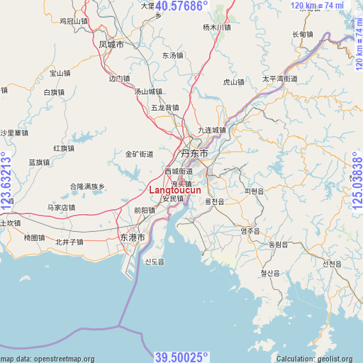
Langtoucun GPS coordinates[2]
40° 2' 26.448" North, 124° 20' 6.9" East
| Map corner | latitude | longitude |
|---|---|---|
| Upper-left | 40.57686°, | 123.63213° |
| Center: | 40.04068°, | 124.33525° |
| Lower-right: | 39.50025°, | 125.03838° |
| Map W x H: | 119.7×119.7 km | = 74.4×74.4mi |
| max Lat: | 53.31946° ⇑13.5% North |
| Langtoucun: | 40.04068° |
| min Lat: | ⇓86.5% South 18.22056° |
| min Long | Langtoucun | max Long |
| 75.07348° | 124.33525° | 134.28917° |
| W 94.2%⇐ | ⇒5.8% E |
Elevation
Elevation of Langtoucun is 5 m = 16 ft, and this is 479.8 m = 1574 ft below average elevation for this country.
| Max E: |
5622 m = 18445 ft | 97.2% |
| Avg. | 484.8 m = 1591 ft | |
| Langtoucun | 5 m = 16 ft | |
Min E: |
-3 m = -10 ft | 2.8% |
See also: Langtoucun elevation on elevation.city.
Geographical zone
Langtoucun is located in North temperate zone (between Tropic of Cancer and the Arctic Circle). Distance of this Northern Tropic circle is 1846.2 km =1147.2 mi to South.| Distance of | km | miles | from Langtoucun |
|---|---|---|---|
| North Pole | 5555 | 3451.7 | to North |
| Arctic Circle | 2949.1 | 1832.5 | to North |
| Tropic Cancer | 1846.2 | 1147.2 | to South |
| Equator | 4452.1 | 2766.4 | to South |


Nearby cities:
15 places around Langtoucun: (largest is in red/bold)
• Baiqi
51.5 km =32 mi,  305°
305°
• Baoshan
53.9 km =33.5 mi, 311°
• Chaoyang
81.1 km =50.4 mi,  304°
304°
• Dandong
11.1 km =6.9 mi,  27°
27°
• Dayingzi
68.9 km =42.8 mi, 296°
• Fengcheng
51.1 km =31.8 mi,  334°
334°
• Heigou
62.1 km =38.6 mi,  274°
274°
• Hongqi
40.7 km =25.3 mi,  285°
285°
• Jiguanshan
64.2 km =39.9 mi, 326°
• Lanqi
47.4 km =29.5 mi,  278°
278°
• Linggou
78.4 km =48.7 mi, 280°
• Liujiahe
76.2 km =47.3 mi,  336°
336°
• Shalizhai
57.2 km =35.5 mi, 285°
• Xinxing
26.5 km =16.5 mi,  223°
223°
• Yanghe
78.9 km =49 mi, 271°
Sources, notices
• [Note1] Compared only with cities in China existing in our database
• [Src1] Map data: © OpenStreetMap contributors (CC-BY-SA)
• [Src2] Other city data from geonames.org with taken over terms of usage.
• [Src3] Geographical zone / Annual Mean Temperature by Robert A. Rohde @ Wikipedia
