Yitong geodata
Yitong (Jilin) is a seat of a third-order administrative division; located in China in Asia/Shanghai (GMT+8) time zone. In our database, there are 1268 cities with bigger population. Compared to other cities in China, 92.2% of cities are located further ↓South; 94.9% of cities are located further ←West and 59.2% of cities have lower elevation than Yitong. Note1


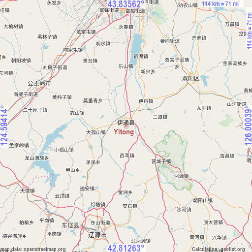
Yitong GPS coordinates[2]
43° 19' 34.608" North, 125° 17' 50.136" East
| Map corner | latitude | longitude |
|---|---|---|
| Upper-left | 43.83562°, | 124.59414° |
| Center: | 43.32628°, | 125.29726° |
| Lower-right: | 42.81263°, | 126.00039° |
| Map W x H: | 113.7×113.7 km | = 70.6×70.6mi |
| max Lat: | 53.31946° ⇑7.8% North |
| Yitong: | 43.32628° |
| min Lat: | ⇓92.2% South 18.22056° |
| min Long | Yitong | max Long |
| 75.07348° | 125.29726° | 134.28917° |
| W 94.9%⇐ | ⇒5.1% E |
Elevation
Elevation of Yitong is 249 m = 817 ft, and this is 235.8 m = 774 ft below average elevation for this country.
| Max E: |
5622 m = 18445 ft | 40.8% |
| Avg. | 484.8 m = 1591 ft | |
| Yitong | 249 m = 817 ft | |
Min E: |
-3 m = -10 ft | 59.2% |
See also: China elevation on elevation.city.
Geographical zone
Yitong is located in North temperate zone (between Tropic of Cancer and the Arctic Circle). Distance of this Northern Tropic circle is 2211.5 km =1374.2 mi to South.| Distance of | km | miles | from Yitong |
|---|---|---|---|
| North Pole | 5189.6 | 3224.7 | to North |
| Arctic Circle | 2583.7 | 1605.4 | to North |
| Tropic Cancer | 2211.5 | 1374.2 | to South |
| Equator | 4817.4 | 2993.4 | to South |


Nearby cities:
15 places around Yitong: (largest is in red/bold)
• Baiquan
56.2 km =34.9 mi,  209°
209°
• Changchun
61.6 km =38.3 mi,  1°
1°
• Dongfeng
78.2 km =48.6 mi,  167°
167°
• Gongzhuling
43.2 km =26.8 mi,  296°
296°
• Liaoyuan
48.8 km =30.3 mi,  195°
195°
• Lishu
78.5 km =48.8 mi,  268°
268°
• Maojiadian
87.3 km =54.2 mi,  248°
248°
• Panshi
74.9 km =46.5 mi,  124°
124°
• Quangou
85.4 km =53.1 mi,  259°
259°
• Shuangyang
37.5 km =23.3 mi,  54°
54°
• Siping
76.7 km =47.7 mi, 256°
• Xia’ertai
91.7 km =57 mi,  242°
242°
• Xifeng
80.5 km =50 mi,  215°
215°
• Xinglongshan
71.3 km =44.3 mi,  10°
10°
• Yantongshan
57.7 km =35.9 mi,  93°
93°
Sources, notices
• [Note1] Compared only with cities in China existing in our database
• [Src1] Map data: © OpenStreetMap contributors (CC-BY-SA)
• [Src2] Other city data from geonames.org with taken over terms of usage.
• [Src3] Geographical zone / Annual Mean Temperature by Robert A. Rohde @ Wikipedia
