Shuangyang geodata
Shuangyang (Jilin) is a populated place; located in China in Asia/Shanghai (GMT+8) time zone. With population of 62,137 people, there are 693 cities with bigger population in this country. Compared to other cities in China, 92.3% of cities are located further ↓South; 95.2% of cities are located further ←West and 55.4% of cities have lower elevation than Shuangyang. Note1


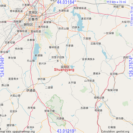
Shuangyang GPS coordinates[2]
43° 31' 27.012" North, 125° 40' 24.996" East
| Map corner | latitude | longitude |
|---|---|---|
| Upper-left | 44.03184°, | 124.97049° |
| Center: | 43.52417°, | 125.67361° |
| Lower-right: | 43.01219°, | 126.37674° |
| Map W x H: | 113.4×113.4 km | = 70.5×70.5mi |
| max Lat: | 53.31946° ⇑7.7% North |
| Shuangyang: | 43.52417° |
| min Lat: | ⇓92.3% South 18.22056° |
| min Long | Shuangyang | max Long |
| 75.07348° | 125.67361° | 134.28917° |
| W 95.2%⇐ | ⇒4.8% E |
Elevation
Elevation of Shuangyang is 210 m = 689 ft, and this is 274.8 m = 902 ft below average elevation for this country.
| Max E: |
5622 m = 18445 ft | 44.6% |
| Avg. | 484.8 m = 1591 ft | |
| Shuangyang | 210 m = 689 ft | |
Min E: |
-3 m = -10 ft | 55.4% |
See also: Shuangyang elevation on elevation.city.
Geographical zone
Shuangyang is located in North temperate zone (between Tropic of Cancer and the Arctic Circle). Distance of this Northern Tropic circle is 2233.5 km =1387.8 mi to South.| Distance of | km | miles | from Shuangyang |
|---|---|---|---|
| North Pole | 5167.6 | 3211 | to North |
| Arctic Circle | 2561.7 | 1591.8 | to North |
| Tropic Cancer | 2233.5 | 1387.8 | to South |
| Equator | 4839.4 | 3007.1 | to South |


Nearby cities:
15 places around Shuangyang: (largest is in red/bold)
• Baiquan
91.7 km =57 mi,  219°
219°
• Changchun
48.6 km =30.2 mi,  324°
324°
• Chaoyang
100 km =62.1 mi,  163°
163°
• Dongfeng
99.2 km =61.6 mi,  187°
187°
• Gongzhuling
68.9 km =42.8 mi,  267°
267°
• Huadian
107 km =66.5 mi,  125°
125°
• Jilin
80 km =49.7 mi,  63°
63°
• Jiutai
71 km =44.1 mi,  10°
10°
• Kouqian
64.4 km =40 mi,  78°
78°
• Liaoyuan
81.6 km =50.7 mi,  212°
212°
• Nong’an
103.6 km =64.4 mi,  337°
337°
• Panshi
71.7 km =44.6 mi,  154°
154°
• Xinglongshan
50.8 km =31.6 mi, 340°
• Yantongshan
37.5 km =23.3 mi, 133°
• Yitong
37.5 km =23.3 mi,  234°
234°
Sources, notices
• [Note1] Compared only with cities in China existing in our database
• [Src1] Map data: © OpenStreetMap contributors (CC-BY-SA)
• [Src2] Other city data from geonames.org with taken over terms of usage.
• [Src3] Geographical zone / Annual Mean Temperature by Robert A. Rohde @ Wikipedia
