Xinglongshan geodata
Xinglongshan (Jilin) is a populated place; located in China in Asia/Shanghai (GMT+8) time zone. With population of 58,432 people, there are 754 cities with bigger population in this country. Compared to other cities in China, 92.7% of cities are located further ↓South; 95% of cities are located further ←West and 57.3% of cities have lower elevation than Xinglongshan. Note1


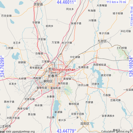
Xinglongshan GPS coordinates[2]
43° 57' 21.996" North, 125° 27' 57.996" East
| Map corner | latitude | longitude |
|---|---|---|
| Upper-left | 44.46011°, | 124.76299° |
| Center: | 43.95611°, | 125.46611° |
| Lower-right: | 43.44779°, | 126.16924° |
| Map W x H: | 112.6×112.6 km | = 70×70mi |
| max Lat: | 53.31946° ⇑7.3% North |
| Xinglongshan: | 43.95611° |
| min Lat: | ⇓92.7% South 18.22056° |
| min Long | Xinglongshan | max Long |
| 75.07348° | 125.46611° | 134.28917° |
| W 95%⇐ | ⇒5% E |
Elevation
Elevation of Xinglongshan is 228 m = 748 ft, and this is 256.8 m = 843 ft below average elevation for this country.
| Max E: |
5622 m = 18445 ft | 42.7% |
| Avg. | 484.8 m = 1591 ft | |
| Xinglongshan | 228 m = 748 ft | |
Min E: |
-3 m = -10 ft | 57.3% |
See also: Xinglongshan elevation on elevation.city.
Geographical zone
Xinglongshan is located in North temperate zone (between Tropic of Cancer and the Arctic Circle). Distance of this Northern Tropic circle is 2281.5 km =1417.7 mi to South.| Distance of | km | miles | from Xinglongshan |
|---|---|---|---|
| North Pole | 5119.6 | 3181.2 | to North |
| Arctic Circle | 2513.7 | 1561.9 | to North |
| Tropic Cancer | 2281.5 | 1417.7 | to South |
| Equator | 4887.5 | 3037 | to South |


Nearby cities:
15 places around Xinglongshan: (largest is in red/bold)
• Changchun
14.3 km =8.9 mi,  233°
233°
• Changling
122 km =75.8 mi,  286°
286°
• Dehui
66.8 km =41.5 mi,  16°
16°
• Gongzhuling
72.5 km =45 mi, 225°
• Jilin
88.4 km =54.9 mi,  97°
97°
• Jishu
113.7 km =70.6 mi,  69°
69°
• Jiutai
36.5 km =22.7 mi,  53°
53°
• Kouqian
87 km =54.1 mi,  113°
113°
• Liaoyuan
120 km =74.6 mi,  192°
192°
• Lishu
116.8 km =72.6 mi, 231°
• Nong’an
53 km =32.9 mi,  333°
333°
• Sanchahe
120.1 km =74.6 mi, 21°
• Shuangyang
50.8 km =31.6 mi,  160°
160°
• Yantongshan
85.8 km =53.3 mi,  149°
149°
• Yitong
71.3 km =44.3 mi, 190°
Sources, notices
• [Note1] Compared only with cities in China existing in our database
• [Src1] Map data: © OpenStreetMap contributors (CC-BY-SA)
• [Src2] Other city data from geonames.org with taken over terms of usage.
• [Src3] Geographical zone / Annual Mean Temperature by Robert A. Rohde @ Wikipedia
