Chelu geodata
Chelu (Heilongjiang) is a seat of a fourth-order administrative division; located in China in Asia/Shanghai (GMT+8) time zone. In our database, there are 1268 cities with bigger population. Compared to other cities in China, 99.4% of cities are located further ↓South; 98.3% of cities are located further ←West and 52.9% of cities have lower elevation than Chelu. Note1


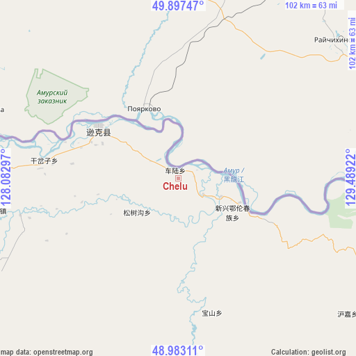
Chelu GPS coordinates[2]
49° 26' 32.712" North, 128° 47' 9.924" East
| Map corner | latitude | longitude |
|---|---|---|
| Upper-left | 49.89747°, | 128.08297° |
| Center: | 49.44242°, | 128.78609° |
| Lower-right: | 48.98311°, | 129.48922° |
| Map W x H: | 101.7×101.7 km | = 63.2×63.2mi |
| max Lat: | 53.31946° ⇑0.6% North |
| Chelu: | 49.44242° |
| min Lat: | ⇓99.4% South 18.22056° |
| min Long | Chelu | max Long |
| 75.07348° | 128.78609° | 134.28917° |
| W 98.3%⇐ | ⇒1.7% E |
Elevation
Elevation of Chelu is 188 m = 617 ft, and this is 296.8 m = 974 ft below average elevation for this country.
| Max E: |
5622 m = 18445 ft | 47.1% |
| Avg. | 484.8 m = 1591 ft | |
| Chelu | 188 m = 617 ft | |
Min E: |
-3 m = -10 ft | 52.9% |
See also: China elevation on elevation.city.
Geographical zone
Chelu is located in North temperate zone (between Tropic of Cancer and the Arctic Circle). Distance of this North polar circle is 1903.7 km =1182.9 mi to North.| Distance of | km | miles | from Chelu |
|---|---|---|---|
| North Pole | 4509.6 | 2802.1 | to North |
| Arctic Circle | 1903.7 | 1182.9 | to North |
| Tropic Cancer | 2891.6 | 1796.8 | to South |
| Equator | 5497.5 | 3416 | to South |


Nearby cities:
15 places around Chelu: (largest is in red/bold)
• Baoshan
40.6 km =25.2 mi,  164°
164°
• Bianjiang
26 km =16.2 mi,  299°
299°
• Changsheng
52.8 km =32.8 mi,  94°
94°
• Ganchazi
37.7 km =23.4 mi,  275°
275°
• Hujia
62 km =38.5 mi,  128°
128°
• Kelin
81.6 km =50.7 mi,  171°
171°
• Qunshan
91.3 km =56.7 mi,  254°
254°
• Songshugou
16 km =9.9 mi,  225°
225°
• Wuyun
64.3 km =40 mi,  106°
106°
• Xiangyang
76.2 km =47.3 mi, 112°
• Xinxing
17.6 km =10.9 mi,  117°
117°
• Xin’e
67.3 km =41.8 mi,  241°
241°
• Xunhe
52.8 km =32.8 mi,  258°
258°
• Yanjiang
73.9 km =45.9 mi, 281°
• Yaotun
93.3 km =58 mi,  269°
269°
Sources, notices
• [Note1] Compared only with cities in China existing in our database
• [Src1] Map data: © OpenStreetMap contributors (CC-BY-SA)
• [Src2] Other city data from geonames.org with taken over terms of usage.
• [Src3] Geographical zone / Annual Mean Temperature by Robert A. Rohde @ Wikipedia
