Baoshan geodata
Baoshan (Heilongjiang) is a seat of a fourth-order administrative division; located in China in Asia/Shanghai (GMT+8) time zone. In our database, there are 1268 cities with bigger population. Compared to other cities in China, 99.1% of cities are located further ↓South; 98.4% of cities are located further ←West and 61.5% of cities have lower elevation than Baoshan. Note1


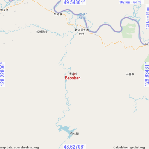
Baoshan GPS coordinates[2]
49° 5' 22.848" North, 128° 55' 52.248" East
| Map corner | latitude | longitude |
|---|---|---|
| Upper-left | 49.54801°, | 128.22806° |
| Center: | 49.08968°, | 128.93118° |
| Lower-right: | 48.62708°, | 129.63431° |
| Map W x H: | 102.4×102.4 km | = 63.6×63.6mi |
| max Lat: | 53.31946° ⇑0.9% North |
| Baoshan: | 49.08968° |
| min Lat: | ⇓99.1% South 18.22056° |
| min Long | Baoshan | max Long |
| 75.07348° | 128.93118° | 134.28917° |
| W 98.4%⇐ | ⇒1.6% E |
Elevation
Elevation of Baoshan is 277 m = 909 ft, and this is 207.8 m = 682 ft below average elevation for this country.
| Max E: |
5622 m = 18445 ft | 38.5% |
| Avg. | 484.8 m = 1591 ft | |
| Baoshan | 277 m = 909 ft | |
Min E: |
-3 m = -10 ft | 61.5% |
See also: China elevation on elevation.city.
Geographical zone
Baoshan is located in North temperate zone (between Tropic of Cancer and the Arctic Circle). Distance of this North polar circle is 1942.9 km =1207.3 mi to North.| Distance of | km | miles | from Baoshan |
|---|---|---|---|
| North Pole | 4548.8 | 2826.5 | to North |
| Arctic Circle | 1942.9 | 1207.3 | to North |
| Tropic Cancer | 2852.3 | 1772.3 | to South |
| Equator | 5458.3 | 3391.6 | to South |


Nearby cities:
15 places around Baoshan: (largest is in red/bold)
• Bianjiang
61.7 km =38.3 mi,  327°
327°
• Changsheng
55.1 km =34.2 mi,  50°
50°
• Chelu
40.6 km =25.2 mi,  344°
344°
• Ganchazi
64.3 km =40 mi,  311°
311°
• Hujia
38 km =23.6 mi,  89°
89°
• Kelin
41.6 km =25.8 mi,  178°
178°
• Qingshan
86.3 km =53.6 mi,  125°
125°
• Songshugou
35.5 km =22.1 mi,  321°
321°
• Wuyun
55.5 km =34.5 mi,  67°
67°
• Xiangyang
60.9 km =37.8 mi,  80°
80°
• Xinqing
99.3 km =61.7 mi,  154°
154°
• Xinxing
31.4 km =19.5 mi,  9°
9°
• Xin’e
69.9 km =43.4 mi,  275°
275°
• Xunhe
68.5 km =42.6 mi,  294°
294°
• Yanjiang
99.1 km =61.6 mi,  302°
302°
Sources, notices
• [Note1] Compared only with cities in China existing in our database
• [Src1] Map data: © OpenStreetMap contributors (CC-BY-SA)
• [Src2] Other city data from geonames.org with taken over terms of usage.
• [Src3] Geographical zone / Annual Mean Temperature by Robert A. Rohde @ Wikipedia
