Hujia geodata
Hujia (Heilongjiang) is a seat of a fourth-order administrative division; located in China in Asia/Shanghai (GMT+8) time zone. In our database, there are 1268 cities with bigger population. Compared to other cities in China, 99.1% of cities are located further ↓South; 98.7% of cities are located further ←West and 61.2% of cities have lower elevation than Hujia. Note1


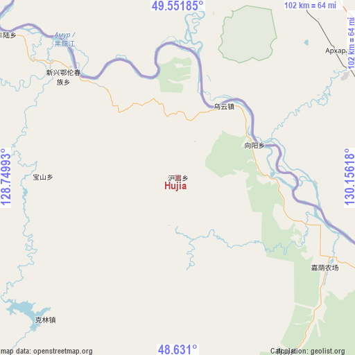
Hujia GPS coordinates[2]
49° 5' 36.816" North, 129° 27' 10.98" East
| Map corner | latitude | longitude |
|---|---|---|
| Upper-left | 49.55185°, | 128.74993° |
| Center: | 49.09356°, | 129.45305° |
| Lower-right: | 48.631°, | 130.15618° |
| Map W x H: | 102.4×102.4 km | = 63.6×63.6mi |
| max Lat: | 53.31946° ⇑0.9% North |
| Hujia: | 49.09356° |
| min Lat: | ⇓99.1% South 18.22056° |
| min Long | Hujia | max Long |
| 75.07348° | 129.45305° | 134.28917° |
| W 98.7%⇐ | ⇒1.3% E |
Elevation
Elevation of Hujia is 274 m = 899 ft, and this is 210.8 m = 692 ft below average elevation for this country.
| Max E: |
5622 m = 18445 ft | 38.8% |
| Avg. | 484.8 m = 1591 ft | |
| Hujia | 274 m = 899 ft | |
Min E: |
-3 m = -10 ft | 61.2% |
See also: China elevation on elevation.city.
Geographical zone
Hujia is located in North temperate zone (between Tropic of Cancer and the Arctic Circle). Distance of this North polar circle is 1942.5 km =1207 mi to North.| Distance of | km | miles | from Hujia |
|---|---|---|---|
| North Pole | 4548.4 | 2826.2 | to North |
| Arctic Circle | 1942.5 | 1207 | to North |
| Tropic Cancer | 2852.8 | 1772.6 | to South |
| Equator | 5458.7 | 3391.9 | to South |


Nearby cities:
15 places around Hujia: (largest is in red/bold)
• Baoshan
38 km =23.6 mi,  269°
269°
• Baoxing
94 km =58.4 mi,  124°
124°
• Bianjiang
87.8 km =54.6 mi,  306°
306°
• Changsheng
35.2 km =21.9 mi,  7°
7°
• Chaoyang
73.1 km =45.4 mi,  108°
108°
• Chelu
62 km =38.5 mi, 308°
• Hongguang
83.5 km =51.9 mi, 112°
• Kelin
56.2 km =34.9 mi,  221°
221°
• Qingshan
59.7 km =37.1 mi,  147°
147°
• Songshugou
65.8 km =40.9 mi,  294°
294°
• Wulaga
92 km =57.2 mi, 147°
• Wuyun
24.5 km =15.2 mi,  33°
33°
• Xiangyang
24.1 km =15 mi,  66°
66°
• Xinqing
89.8 km =55.8 mi,  176°
176°
• Xinxing
44.8 km =27.8 mi, 312°
Sources, notices
• [Note1] Compared only with cities in China existing in our database
• [Src1] Map data: © OpenStreetMap contributors (CC-BY-SA)
• [Src2] Other city data from geonames.org with taken over terms of usage.
• [Src3] Geographical zone / Annual Mean Temperature by Robert A. Rohde @ Wikipedia
