Kelin geodata
Kelin (Heilongjiang) is a seat of a fourth-order administrative division; located in China in Asia/Shanghai (GMT+8) time zone. In our database, there are 1268 cities with bigger population. Compared to other cities in China, 99% of cities are located further ↓South; 98.4% of cities are located further ←West and 68.8% of cities have lower elevation than Kelin. Note1


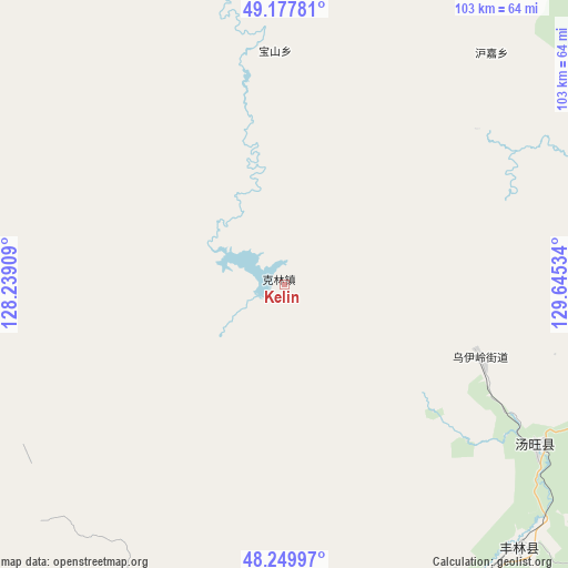
Kelin GPS coordinates[2]
48° 42' 57.708" North, 128° 56' 31.956" East
| Map corner | latitude | longitude |
|---|---|---|
| Upper-left | 49.17781°, | 128.23909° |
| Center: | 48.71603°, | 128.94221° |
| Lower-right: | 48.24997°, | 129.64534° |
| Map W x H: | 103.2×103.2 km | = 64.1×64.1mi |
| max Lat: | 53.31946° ⇑1% North |
| Kelin: | 48.71603° |
| min Lat: | ⇓99% South 18.22056° |
| min Long | Kelin | max Long |
| 75.07348° | 128.94221° | 134.28917° |
| W 98.4%⇐ | ⇒1.6% E |
Elevation
Elevation of Kelin is 390 m = 1280 ft, and this is 94.8 m = 311 ft below average elevation for this country.
| Max E: |
5622 m = 18445 ft | 31.2% |
| Avg. | 484.8 m = 1591 ft | |
| Kelin | 390 m = 1280 ft | |
Min E: |
-3 m = -10 ft | 68.8% |
See also: China elevation on elevation.city.
Geographical zone
Kelin is located in North temperate zone (between Tropic of Cancer and the Arctic Circle). Distance of this North polar circle is 1984.5 km =1233.1 mi to North.| Distance of | km | miles | from Kelin |
|---|---|---|---|
| North Pole | 4590.3 | 2852.3 | to North |
| Arctic Circle | 1984.5 | 1233.1 | to North |
| Tropic Cancer | 2810.8 | 1746.5 | to South |
| Equator | 5416.7 | 3365.8 | to South |


Nearby cities:
15 places around Kelin: (largest is in red/bold)
• Baoshan
41.6 km =25.8 mi,  358°
358°
• Changsheng
87.5 km =54.4 mi,  28°
28°
• Chelu
81.6 km =50.7 mi,  351°
351°
• Hongshan
82.5 km =51.3 mi,  175°
175°
• Hujia
56.2 km =34.9 mi,  41°
41°
• Qingshan
70.5 km =43.8 mi,  96°
96°
• Songshugou
73.1 km =45.4 mi,  341°
341°
• Wulaga
94.6 km =58.8 mi,  111°
111°
• Wuyun
80.5 km =50 mi, 39°
• Xiangyang
78.8 km =49 mi,  49°
49°
• Xinqing
64.1 km =39.8 mi,  138°
138°
• Xinxing
72.7 km =45.2 mi,  3°
3°
• Xin’e
85.5 km =53.1 mi,  304°
304°
• Xunhe
94.4 km =58.7 mi,  317°
317°
• Youhao
96.3 km =59.8 mi, 184°
Sources, notices
• [Note1] Compared only with cities in China existing in our database
• [Src1] Map data: © OpenStreetMap contributors (CC-BY-SA)
• [Src2] Other city data from geonames.org with taken over terms of usage.
• [Src3] Geographical zone / Annual Mean Temperature by Robert A. Rohde @ Wikipedia
