Burgastai geodata
Burgastai (Inner Mongolia) is a seat of a fourth-order administrative division; located in China in Asia/Shanghai (GMT+8) time zone. In our database, there are 1268 cities with bigger population. Compared to other cities in China, 94% of cities are located further ↓South; 75.9% of cities are located further ←West and 87.6% of cities have lower elevation than Burgastai. Note1


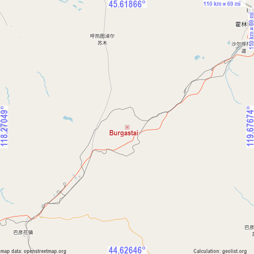
Burgastai GPS coordinates[2]
45° 7' 28.992" North, 118° 58' 24.996" East
| Map corner | latitude | longitude |
|---|---|---|
| Upper-left | 45.61866°, | 118.27049° |
| Center: | 45.12472°, | 118.97361° |
| Lower-right: | 44.62646°, | 119.67674° |
| Map W x H: | 110.3×110.3 km | = 68.5×68.5mi |
| max Lat: | 53.31946° ⇑6% North |
| Burgastai: | 45.12472° |
| min Lat: | ⇓94% South 18.22056° |
| min Long | Burgastai | max Long |
| 75.07348° | 118.97361° | 134.28917° |
| W 75.9%⇐ | ⇒24.1% E |
Elevation
Elevation of Burgastai is 1155 m = 3789 ft, and this is 670.2 m = 2199 ft above average elevation for this country.
| Max E: |
5622 m = 18445 ft | 12.4% |
| Burgastai | 1155 m 3789 ft | |
| Avg. | 484.8 m = 1591 ft | |
Min E: |
-3 m = -10 ft | 87.6% |
See also: China elevation on elevation.city.
Geographical zone
Burgastai is located in North temperate zone (between Tropic of Cancer and the Arctic Circle). Distance of this North polar circle is 2383.8 km =1481.2 mi to North.| Distance of | km | miles | from Burgastai |
|---|---|---|---|
| North Pole | 4989.7 | 3100.5 | to North |
| Arctic Circle | 2383.8 | 1481.2 | to North |
| Tropic Cancer | 2411.5 | 1498.4 | to South |
| Equator | 5017.4 | 3117.7 | to South |


Nearby cities:
15 places around Burgastai: (largest is in red/bold)
• Bala Ga’er Gaole
121.8 km =75.7 mi,  240°
240°
• Bayan Huxu
120.2 km =74.7 mi,  257°
257°
• Bayan Tal
141.7 km =88 mi,  124°
124°
• Bayart Huxu
108 km =67.1 mi,  91°
91°
• Eren Gobi
128.8 km =80 mi,  336°
336°
• Har Nur
103.7 km =64.4 mi,  56°
56°
• Holt
78.9 km =49 mi,  166°
166°
• Jirin Gol
167.3 km =104 mi, 244°
• Lindong
128 km =79.5 mi, 172°
• Lubei
166.4 km =103.4 mi,  110°
110°
• Mositai
70.9 km =44.1 mi,  49°
49°
• Subrag
110.4 km =68.6 mi,  201°
201°
• Tianshan
163.7 km =101.7 mi,  147°
147°
• Tule Mod
155.3 km =96.5 mi,  72°
72°
• Uliastai
173.8 km =108 mi,  285°
285°
Sources, notices
• [Note1] Compared only with cities in China existing in our database
• [Src1] Map data: © OpenStreetMap contributors (CC-BY-SA)
• [Src2] Other city data from geonames.org with taken over terms of usage.
• [Src3] Geographical zone / Annual Mean Temperature by Robert A. Rohde @ Wikipedia
