Lindong geodata
Lindong (Inner Mongolia) is a seat of a third-order administrative division; located in China in Asia/Shanghai (GMT+8) time zone. In our database, there are 1268 cities with bigger population. Compared to other cities in China, 92.7% of cities are located further ↓South; 77% of cities are located further ←West and 85.6% of cities have lower elevation than Lindong. Note1


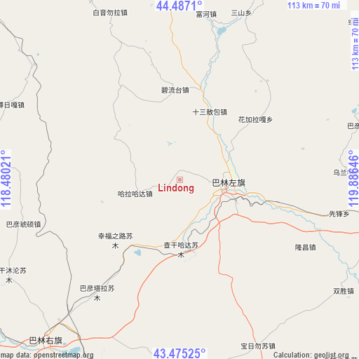
Lindong GPS coordinates[2]
43° 58' 59.988" North, 119° 10' 59.988" East
| Map corner | latitude | longitude |
|---|---|---|
| Upper-left | 44.4871°, | 118.48021° |
| Center: | 43.98333°, | 119.18333° |
| Lower-right: | 43.47525°, | 119.88646° |
| Map W x H: | 112.5×112.5 km | = 69.9×69.9mi |
| max Lat: | 53.31946° ⇑7.3% North |
| Lindong: | 43.98333° |
| min Lat: | ⇓92.7% South 18.22056° |
| min Long | Lindong | max Long |
| 75.07348° | 119.18333° | 134.28917° |
| W 77%⇐ | ⇒23% E |
Elevation
Elevation of Lindong is 1019 m = 3343 ft, and this is 534.2 m = 1753 ft above average elevation for this country.
| Max E: |
5622 m = 18445 ft | 14.4% |
| Lindong | 1019 m 3343 ft | |
| Avg. | 484.8 m = 1591 ft | |
Min E: |
-3 m = -10 ft | 85.6% |
See also: China elevation on elevation.city.
Geographical zone
Lindong is located in North temperate zone (between Tropic of Cancer and the Arctic Circle). Distance of this Northern Tropic circle is 2284.6 km =1419.6 mi to South.| Distance of | km | miles | from Lindong |
|---|---|---|---|
| North Pole | 5116.6 | 3179.3 | to North |
| Arctic Circle | 2510.7 | 1560.1 | to North |
| Tropic Cancer | 2284.6 | 1419.6 | to South |
| Equator | 4890.5 | 3038.8 | to South |


Nearby cities:
15 places around Lindong: (largest is in red/bold)
• Baga Borihe
161.8 km =100.5 mi,  136°
136°
• Bala Ga’er Gaole
141.4 km =87.9 mi,  298°
298°
• Bayan Huxu
168 km =104.4 mi,  306°
306°
• Bayan Tal
111.1 km =69 mi,  65°
65°
• Bayart Huxu
154.8 km =96.2 mi,  36°
36°
• Burgastai
128 km =79.5 mi,  352°
352°
• Daban
65 km =40.4 mi,  219°
219°
• Holt
50.1 km =31.1 mi,  1°
1°
• Jingpeng
157 km =97.6 mi,  238°
238°
• Kailu
167.9 km =104.3 mi,  105°
105°
• Linxi
105.9 km =65.8 mi, 240°
• Lubei
157.2 km =97.7 mi,  63°
63°
• Subrag
62.1 km =38.6 mi,  292°
292°
• Tianshan
73.6 km =45.7 mi,  98°
98°
• Wudan
117.3 km =72.9 mi,  186°
186°
Sources, notices
• [Note1] Compared only with cities in China existing in our database
• [Src1] Map data: © OpenStreetMap contributors (CC-BY-SA)
• [Src2] Other city data from geonames.org with taken over terms of usage.
• [Src3] Geographical zone / Annual Mean Temperature by Robert A. Rohde @ Wikipedia
