Liujiahe geodata
Liujiahe (Liaoning) is a seat of a fourth-order administrative division; located in China in Asia/Shanghai (GMT+8) time zone. In our database, there are 1268 cities with bigger population. Compared to other cities in China, 88.4% of cities are located further ↓South; 93.8% of cities are located further ←West and 54.8% of cities have higher elevation than Liujiahe. Note1


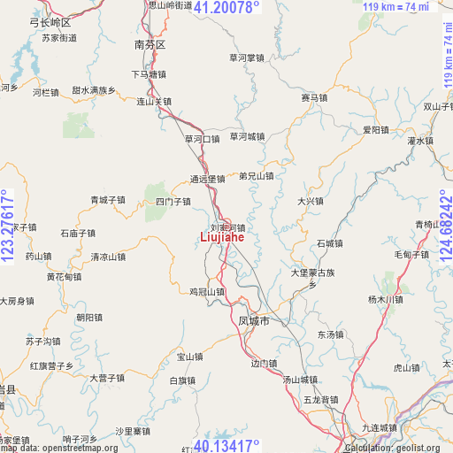
Liujiahe GPS coordinates[2]
40° 40' 10.596" North, 123° 58' 45.444" East
| Map corner | latitude | longitude |
|---|---|---|
| Upper-left | 41.20078°, | 123.27617° |
| Center: | 40.66961°, | 123.97929° |
| Lower-right: | 40.13417°, | 124.68242° |
| Map W x H: | 118.6×118.6 km | = 73.7×73.7mi |
| max Lat: | 53.31946° ⇑11.6% North |
| Liujiahe: | 40.66961° |
| min Lat: | ⇓88.4% South 18.22056° |
| min Long | Liujiahe | max Long |
| 75.07348° | 123.97929° | 134.28917° |
| W 93.8%⇐ | ⇒6.2% E |
Elevation
Elevation of Liujiahe is 133 m = 436 ft, and this is 351.8 m = 1154 ft below average elevation for this country.
| Max E: |
5622 m = 18445 ft | 54.8% |
| Avg. | 484.8 m = 1591 ft | |
| Liujiahe | 133 m = 436 ft | |
Min E: |
-3 m = -10 ft | 45.2% |
See also: China elevation on elevation.city.
Geographical zone
Liujiahe is located in North temperate zone (between Tropic of Cancer and the Arctic Circle). Distance of this Northern Tropic circle is 1916.1 km =1190.6 mi to South.| Distance of | km | miles | from Liujiahe |
|---|---|---|---|
| North Pole | 5485 | 3408.2 | to North |
| Arctic Circle | 2879.1 | 1789 | to North |
| Tropic Cancer | 1916.1 | 1190.6 | to South |
| Equator | 4522 | 2809.8 | to South |


Nearby cities:
15 places around Liujiahe: (largest is in red/bold)
• Baiqi
41.7 km =25.9 mi,  196°
196°
• Baoshan
35.4 km =22 mi, 196°
• Caohekou
24.1 km =15 mi,  344°
344°
• Caohezhang
44.6 km =27.7 mi,  6°
6°
• Chaoyang
43.2 km =26.8 mi,  236°
236°
• Dayingzi
50.5 km =31.4 mi,  218°
218°
• Fengcheng
25.3 km =15.7 mi,  162°
162°
• Hanghuadian
44.8 km =27.8 mi,  253°
253°
• Jiguanshan
17.5 km =10.9 mi, 198°
• Jiucaigou
51.9 km =32.2 mi,  260°
260°
• Qingchengzi
32.3 km =20.1 mi,  282°
282°
• Shimiaozi
39.3 km =24.4 mi,  267°
267°
• Simenzi
15.4 km =9.6 mi,  297°
297°
• Tanggou
32.1 km =19.9 mi, 256°
• Tongyuanpu
14.6 km =9.1 mi, 338°
Sources, notices
• [Note1] Compared only with cities in China existing in our database
• [Src1] Map data: © OpenStreetMap contributors (CC-BY-SA)
• [Src2] Other city data from geonames.org with taken over terms of usage.
• [Src3] Geographical zone / Annual Mean Temperature by Robert A. Rohde @ Wikipedia
