Yanmen geodata
Yanmen (Yunnan) is a seat of a fourth-order administrative division; located in China in Asia/Shanghai (GMT+8) time zone. In our database, there are 1268 cities with bigger population. Compared to other cities in China, 73.5% of cities are located further ↑North; 95.1% of cities are located further →East and 99.3% of cities have lower elevation than Yanmen. Note1


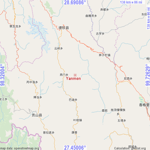
Yanmen GPS coordinates[2]
28° 4' 20.1" North, 99° 1' 23.376" East
| Map corner | latitude | longitude |
|---|---|---|
| Upper-left | 28.69086°, | 98.32004° |
| Center: | 28.07225°, | 99.02316° |
| Lower-right: | 27.45006°, | 99.72629° |
| Map W x H: | 138×138 km | = 85.7×85.7mi |
| max Lat: | 53.31946° ⇑73.5% North |
| Yanmen: | 28.07225° |
| min Lat: | ⇓26.5% South 18.22056° |
| min Long | Yanmen | max Long |
| 75.07348° | 99.02316° | 134.28917° |
| W 4.9%⇐ | ⇒95.1% E |
Elevation
Elevation of Yanmen is 4339 m = 14236 ft, and this is 3854.2 m = 12645 ft above average elevation for this country.
| Max E: |
5622 m = 18445 ft | 0.7% |
| Yanmen | 4339 m 14236 ft | |
| Avg. | 484.8 m = 1591 ft | |
Min E: |
-3 m = -10 ft | 99.3% |
See also: China elevation on elevation.city.
Geographical zone
Yanmen is located in North temperate zone (between Tropic of Cancer and the Arctic Circle). Distance of this Northern Tropic circle is 515.4 km =320.3 mi to South.| Distance of | km | miles | from Yanmen |
|---|---|---|---|
| North Pole | 6885.7 | 4278.6 | to North |
| Arctic Circle | 4279.8 | 2659.3 | to North |
| Tropic Cancer | 515.4 | 320.3 | to South |
| Equator | 3121.3 | 1939.5 | to South |


Nearby cities:
15 places around Yanmen: (largest is in red/bold)
• Badi
22.4 km =13.9 mi,  162°
162°
• Bengshutang
47.8 km =29.7 mi,  94°
94°
• Benzilan
38.4 km =23.9 mi,  61°
61°
• Cikai
46 km =28.6 mi,  221°
221°
• Foshan
76.6 km =47.6 mi,  343°
343°
• Kangpu
53.6 km =33.3 mi,  171°
171°
• Lazanzhong
71.5 km =44.4 mi,  76°
76°
• Shangri-La
72.6 km =45.1 mi,  112°
112°
• Shengping
47.2 km =29.3 mi,  346°
346°
• Songmai
75.9 km =47.2 mi,  19°
19°
• Tuoding
56.1 km =34.9 mi,  128°
128°
• Wujing
65.2 km =40.5 mi, 129°
• Xiaruo
44 km =27.3 mi, 131°
• Yezhi
42.4 km =26.3 mi, 166°
• Yunling
25 km =15.5 mi, 348°
Sources, notices
• [Note1] Compared only with cities in China existing in our database
• [Src1] Map data: © OpenStreetMap contributors (CC-BY-SA)
• [Src2] Other city data from geonames.org with taken over terms of usage.
• [Src3] Geographical zone / Annual Mean Temperature by Robert A. Rohde @ Wikipedia
