Shengping geodata
Shengping (Yunnan) is a seat of a third-order administrative division; located in China in Asia/Shanghai (GMT+8) time zone. In our database, there are 1268 cities with bigger population. Compared to other cities in China, 69.8% of cities are located further ↑North; 95.1% of cities are located further →East and 97.5% of cities have lower elevation than Shengping. Note1


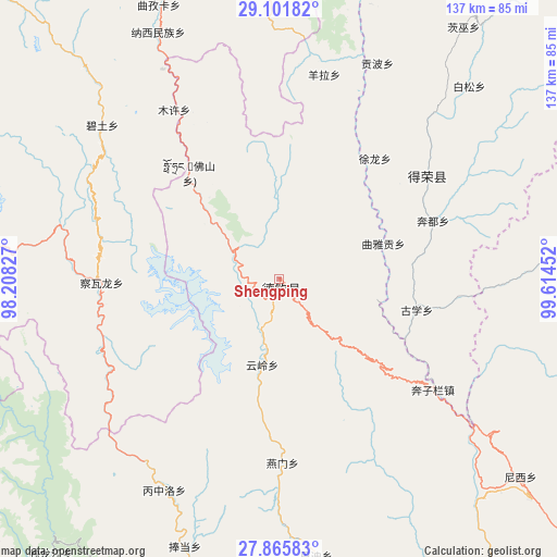
Shengping GPS coordinates[2]
28° 29' 8.268" North, 98° 54' 41.004" East
| Map corner | latitude | longitude |
|---|---|---|
| Upper-left | 29.10182°, | 98.20827° |
| Center: | 28.48563°, | 98.91139° |
| Lower-right: | 27.86583°, | 99.61452° |
| Map W x H: | 137.4×137.4 km | = 85.4×85.4mi |
| max Lat: | 53.31946° ⇑69.8% North |
| Shengping: | 28.48563° |
| min Lat: | ⇓30.2% South 18.22056° |
| min Long | Shengping | max Long |
| 75.07348° | 98.91139° | 134.28917° |
| W 4.9%⇐ | ⇒95.1% E |
Elevation
Elevation of Shengping is 3362 m = 11030 ft, and this is 2877.2 m = 9440 ft above average elevation for this country.
| Max E: |
5622 m = 18445 ft | 2.5% |
| Shengping | 3362 m 11030 ft | |
| Avg. | 484.8 m = 1591 ft | |
Min E: |
-3 m = -10 ft | 97.5% |
See also: China elevation on elevation.city.
Geographical zone
Shengping is located in North temperate zone (between Tropic of Cancer and the Arctic Circle). Distance of this Northern Tropic circle is 561.4 km =348.8 mi to South.| Distance of | km | miles | from Shengping |
|---|---|---|---|
| North Pole | 6839.8 | 4250.1 | to North |
| Arctic Circle | 4233.9 | 2630.8 | to North |
| Tropic Cancer | 561.4 | 348.8 | to South |
| Equator | 3167.3 | 1968.1 | to South |


Nearby cities:
15 places around Shengping: (largest is in red/bold)
• Badi
69.6 km =43.2 mi,  165°
165°
• Baiyu
75 km =46.6 mi,  82°
82°
• Bengshutang
76.9 km =47.8 mi,  130°
130°
• Benzilan
52.6 km =32.7 mi,  121°
121°
• Cikai
82.7 km =51.4 mi,  193°
193°
• Dongwang
81.7 km =50.8 mi, 84°
• Foshan
29.5 km =18.3 mi,  339°
339°
• Gezan
93.3 km =58 mi,  109°
109°
• Lazanzhong
85.5 km =53.1 mi, 110°
• Songmai
44.6 km =27.7 mi,  55°
55°
• Xiaruo
87 km =54.1 mi,  149°
149°
• Yangla
54.9 km =34.1 mi,  22°
22°
• Yanmen
47.2 km =29.3 mi, 166°
• Yezhi
89.6 km =55.7 mi, 166°
• Yunling
22.2 km =13.8 mi,  164°
164°
In other languages:
- In Chinese: Te-ch’in, Te-ch’in-she-chih-chü, Te-ch’in-hsien-tsang-tsu-tzu-chih-ch’ü, 升平, 德钦
Sources, notices
• [Note1] Compared only with cities in China existing in our database
• [Src1] Map data: © OpenStreetMap contributors (CC-BY-SA)
• [Src2] Other city data from geonames.org with taken over terms of usage.
• [Src3] Geographical zone / Annual Mean Temperature by Robert A. Rohde @ Wikipedia
