Yunling geodata
Yunling (Yunnan) is a seat of a fourth-order administrative division; located in China in Asia/Shanghai (GMT+8) time zone. In our database, there are 1268 cities with bigger population. Compared to other cities in China, 71.6% of cities are located further ↑North; 95.1% of cities are located further →East and 100% of cities have lower elevation than Yunling. Note1


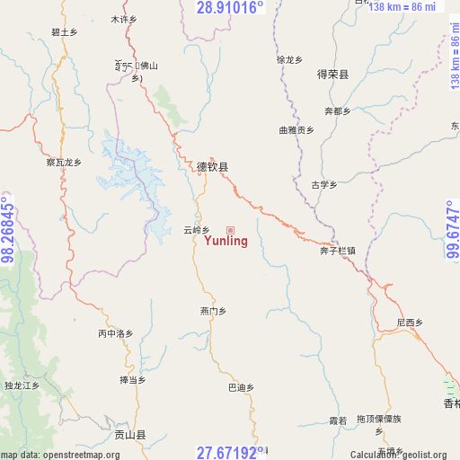
Yunling GPS coordinates[2]
28° 17' 34.224" North, 98° 58' 17.652" East
| Map corner | latitude | longitude |
|---|---|---|
| Upper-left | 28.91016°, | 98.26845° |
| Center: | 28.29284°, | 98.97157° |
| Lower-right: | 27.67192°, | 99.6747° |
| Map W x H: | 137.7×137.7 km | = 85.6×85.6mi |
| max Lat: | 53.31946° ⇑71.6% North |
| Yunling: | 28.29284° |
| min Lat: | ⇓28.4% South 18.22056° |
| min Long | Yunling | max Long |
| 75.07348° | 98.97157° | 134.28917° |
| W 4.9%⇐ | ⇒95.1% E |
Elevation
Elevation of Yunling is 5050 m = 16568 ft, and this is 4565.2 m = 14978 ft above average elevation for this country.
| Max E: |
5622 m = 18445 ft | 0% |
| Yunling | 5050 m 16568 ft | |
| Avg. | 484.8 m = 1591 ft | |
Min E: |
-3 m = -10 ft | 100% |
See also: China elevation on elevation.city.
Geographical zone
Yunling is located in North temperate zone (between Tropic of Cancer and the Arctic Circle). Distance of this Northern Tropic circle is 539.9 km =335.5 mi to South.| Distance of | km | miles | from Yunling |
|---|---|---|---|
| North Pole | 6861.2 | 4263.4 | to North |
| Arctic Circle | 4255.3 | 2644.1 | to North |
| Tropic Cancer | 539.9 | 335.5 | to South |
| Equator | 3145.9 | 1954.8 | to South |


Nearby cities:
15 places around Yunling: (largest is in red/bold)
• Badi
47.4 km =29.5 mi,  165°
165°
• Baiyu
75.4 km =46.9 mi,  65°
65°
• Bengshutang
59.8 km =37.2 mi,  118°
118°
• Benzilan
39.4 km =24.5 mi,  99°
99°
• Cikai
64.2 km =39.9 mi,  203°
203°
• Foshan
51.6 km =32.1 mi,  341°
341°
• Kangpu
78.6 km =48.8 mi, 170°
• Lazanzhong
74.9 km =46.5 mi, 96°
• Shengping
22.2 km =13.8 mi, 344°
• Songmai
56.1 km =34.9 mi,  33°
33°
• Tuoding
77 km =47.8 mi,  140°
140°
• Xiaruo
65.8 km =40.9 mi, 144°
• Yangla
73.8 km =45.9 mi,  11°
11°
• Yanmen
25 km =15.5 mi, 168°
• Yezhi
67.4 km =41.9 mi, 166°
Sources, notices
• [Note1] Compared only with cities in China existing in our database
• [Src1] Map data: © OpenStreetMap contributors (CC-BY-SA)
• [Src2] Other city data from geonames.org with taken over terms of usage.
• [Src3] Geographical zone / Annual Mean Temperature by Robert A. Rohde @ Wikipedia
