Lazanzhong geodata
Lazanzhong (Yunnan) is a seat of a fourth-order administrative division; located in China in Asia/Shanghai (GMT+8) time zone. In our database, there are 1268 cities with bigger population. Compared to other cities in China, 72.2% of cities are located further ↑North; 94.7% of cities are located further →East and 97.1% of cities have lower elevation than Lazanzhong. Note1


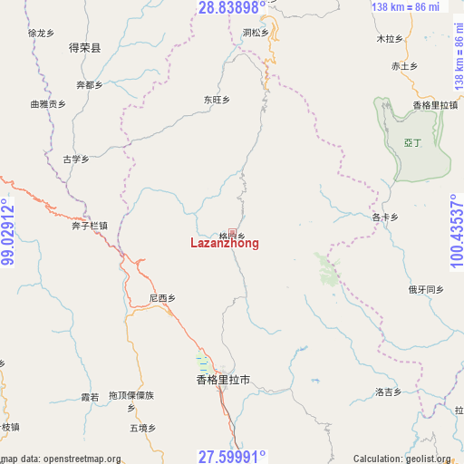
Lazanzhong GPS coordinates[2]
28° 13' 16.464" North, 99° 43' 56.064" East
| Map corner | latitude | longitude |
|---|---|---|
| Upper-left | 28.83898°, | 99.02912° |
| Center: | 28.22124°, | 99.73224° |
| Lower-right: | 27.59991°, | 100.43537° |
| Map W x H: | 137.8×137.8 km | = 85.6×85.6mi |
| max Lat: | 53.31946° ⇑72.2% North |
| Lazanzhong: | 28.22124° |
| min Lat: | ⇓27.8% South 18.22056° |
| min Long | Lazanzhong | max Long |
| 75.07348° | 99.73224° | 134.28917° |
| W 5.3%⇐ | ⇒94.7% E |
Elevation
Elevation of Lazanzhong is 3108 m = 10197 ft, and this is 2623.2 m = 8606 ft above average elevation for this country.
| Max E: |
5622 m = 18445 ft | 2.9% |
| Lazanzhong | 3108 m 10197 ft | |
| Avg. | 484.8 m = 1591 ft | |
Min E: |
-3 m = -10 ft | 97.1% |
See also: China elevation on elevation.city.
Geographical zone
Lazanzhong is located in North temperate zone (between Tropic of Cancer and the Arctic Circle). Distance of this Northern Tropic circle is 532 km =330.6 mi to South.| Distance of | km | miles | from Lazanzhong |
|---|---|---|---|
| North Pole | 6869.2 | 4268.3 | to North |
| Arctic Circle | 4263.3 | 2649.1 | to North |
| Tropic Cancer | 532 | 330.6 | to South |
| Equator | 3137.9 | 1949.8 | to South |


Nearby cities:
15 places around Lazanzhong: (largest is in red/bold)
• Badi
73.5 km =45.7 mi,  238°
238°
• Baiyu
40 km =24.9 mi,  351°
351°
• Bengshutang
30.1 km =18.7 mi,  226°
226°
• Benzilan
35.7 km =22.2 mi,  272°
272°
• Dongwang
37.8 km =23.5 mi,  1°
1°
• Gezan
7.8 km =4.8 mi,  104°
104°
• Jiantang
44.5 km =27.7 mi,  175°
175°
• Shangri-La
44.1 km =27.4 mi, 183°
• Songmai
70.1 km =43.6 mi,  321°
321°
• Tuoding
57.4 km =35.7 mi,  206°
206°
• Wujing
60.8 km =37.8 mi,  198°
198°
• Xiaruo
58.8 km =36.5 mi,  218°
218°
• Yanmen
71.5 km =44.4 mi,  256°
256°
• Yunling
74.9 km =46.5 mi,  276°
276°
• Zhongcun
66.1 km =41.1 mi,  135°
135°
Sources, notices
• [Note1] Compared only with cities in China existing in our database
• [Src1] Map data: © OpenStreetMap contributors (CC-BY-SA)
• [Src2] Other city data from geonames.org with taken over terms of usage.
• [Src3] Geographical zone / Annual Mean Temperature by Robert A. Rohde @ Wikipedia
