Baiyu geodata
Baiyu (Yunnan) is a seat of a fourth-order administrative division; located in China in Asia/Shanghai (GMT+8) time zone. In our database, there are 1268 cities with bigger population. Compared to other cities in China, 69.1% of cities are located further ↑North; 94.7% of cities are located further →East and 96.8% of cities have lower elevation than Baiyu. Note1


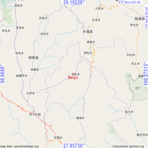
Baiyu GPS coordinates[2]
28° 34' 35.868" North, 99° 40' 19.272" East
| Map corner | latitude | longitude |
|---|---|---|
| Upper-left | 29.19228°, | 98.9689° |
| Center: | 28.57663°, | 99.67202° |
| Lower-right: | 27.95736°, | 100.37515° |
| Map W x H: | 137.3×137.3 km | = 85.3×85.3mi |
| max Lat: | 53.31946° ⇑69.1% North |
| Baiyu: | 28.57663° |
| min Lat: | ⇓30.9% South 18.22056° |
| min Long | Baiyu | max Long |
| 75.07348° | 99.67202° | 134.28917° |
| W 5.3%⇐ | ⇒94.7% E |
Elevation
Elevation of Baiyu is 2966 m = 9731 ft, and this is 2481.2 m = 8140 ft above average elevation for this country.
| Max E: |
5622 m = 18445 ft | 3.2% |
| Baiyu | 2966 m 9731 ft | |
| Avg. | 484.8 m = 1591 ft | |
Min E: |
-3 m = -10 ft | 96.8% |
See also: China elevation on elevation.city.
Geographical zone
Baiyu is located in North temperate zone (between Tropic of Cancer and the Arctic Circle). Distance of this Northern Tropic circle is 571.5 km =355.1 mi to South.| Distance of | km | miles | from Baiyu |
|---|---|---|---|
| North Pole | 6829.6 | 4243.7 | to North |
| Arctic Circle | 4223.8 | 2624.5 | to North |
| Tropic Cancer | 571.5 | 355.1 | to South |
| Equator | 3177.4 | 1974.3 | to South |


Nearby cities:
15 places around Baiyu: (largest is in red/bold)
• Bengshutang
62.1 km =38.6 mi,  194°
194°
• Benzilan
48.1 km =29.9 mi,  218°
218°
• Dongwang
7.2 km =4.5 mi,  103°
103°
• Foshan
86.3 km =53.6 mi,  281°
281°
• Gezan
43.6 km =27.1 mi,  162°
162°
• Jiantang
84.4 km =52.4 mi,  173°
173°
• Lazanzhong
40 km =24.9 mi, 171°
• Sangpi
41.6 km =25.8 mi,  17°
17°
• Shangri-La
83.6 km =51.9 mi,  177°
177°
• Shengping
75 km =46.6 mi,  262°
262°
• Songmai
40.6 km =25.2 mi,  292°
292°
• Xiaruo
90.7 km =56.4 mi,  199°
199°
• Yangla
66.8 km =41.5 mi,  307°
307°
• Yanmen
84.7 km =52.6 mi,  228°
228°
• Yunling
75.4 km =46.9 mi,  245°
245°
Sources, notices
• [Note1] Compared only with cities in China existing in our database
• [Src1] Map data: © OpenStreetMap contributors (CC-BY-SA)
• [Src2] Other city data from geonames.org with taken over terms of usage.
• [Src3] Geographical zone / Annual Mean Temperature by Robert A. Rohde @ Wikipedia
