Yangla geodata
Yangla (Yunnan) is a seat of a fourth-order administrative division; located in China in Asia/Shanghai (GMT+8) time zone. In our database, there are 1268 cities with bigger population. Compared to other cities in China, 66% of cities are located further ↑North; 95% of cities are located further →East and 95.4% of cities have lower elevation than Yangla. Note1


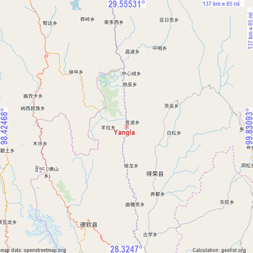
Yangla GPS coordinates[2]
28° 56' 30.588" North, 99° 7' 40.08" East
| Map corner | latitude | longitude |
|---|---|---|
| Upper-left | 29.55531°, | 98.42468° |
| Center: | 28.94183°, | 99.1278° |
| Lower-right: | 28.3247°, | 99.83093° |
| Map W x H: | 136.8×136.8 km | = 85×85mi |
| max Lat: | 53.31946° ⇑66% North |
| Yangla: | 28.94183° |
| min Lat: | ⇓34% South 18.22056° |
| min Long | Yangla | max Long |
| 75.07348° | 99.1278° | 134.28917° |
| W 5%⇐ | ⇒95% E |
Elevation
Elevation of Yangla is 2267 m = 7438 ft, and this is 1782.2 m = 5847 ft above average elevation for this country.
| Max E: |
5622 m = 18445 ft | 4.6% |
| Yangla | 2267 m 7438 ft | |
| Avg. | 484.8 m = 1591 ft | |
Min E: |
-3 m = -10 ft | 95.4% |
See also: China elevation on elevation.city.
Geographical zone
Yangla is located in North temperate zone (between Tropic of Cancer and the Arctic Circle). Distance of this Northern Tropic circle is 612.1 km =380.3 mi to South.| Distance of | km | miles | from Yangla |
|---|---|---|---|
| North Pole | 6789 | 4218.5 | to North |
| Arctic Circle | 4183.1 | 2599.3 | to North |
| Tropic Cancer | 612.1 | 380.3 | to South |
| Equator | 3218 | 1999.6 | to South |


Nearby cities:
15 places around Yangla: (largest is in red/bold)
• Badi
118.1 km =73.4 mi,  181°
181°
• Baiyu
66.8 km =41.5 mi,  127°
127°
• Bengshutang
107.3 km =66.7 mi,  159°
159°
• Benzilan
81.9 km =50.9 mi, 163°
• Dongwang
73.4 km =45.6 mi, 125°
• Foshan
38.9 km =24.2 mi,  233°
233°
• Gartog
97.4 km =60.5 mi,  327°
327°
• Gezan
105.7 km =65.7 mi,  140°
140°
• Lazanzhong
99.5 km =61.8 mi, 143°
• Sangpi
65.4 km =40.6 mi,  90°
90°
• Shengping
54.9 km =34.1 mi,  202°
202°
• Songmai
29.6 km =18.4 mi,  148°
148°
• Xiaruo
128 km =79.5 mi,  169°
169°
• Yanmen
97.2 km =60.4 mi,  186°
186°
• Yunling
73.8 km =45.9 mi, 191°
Sources, notices
• [Note1] Compared only with cities in China existing in our database
• [Src1] Map data: © OpenStreetMap contributors (CC-BY-SA)
• [Src2] Other city data from geonames.org with taken over terms of usage.
• [Src3] Geographical zone / Annual Mean Temperature by Robert A. Rohde @ Wikipedia
