Muping geodata
Muping (Sichuan) is a seat of a third-order administrative division; located in China in Asia/Shanghai (GMT+8) time zone. In our database, there are 1268 cities with bigger population. Compared to other cities in China, 50.6% of cities are located further ↑North; 91.8% of cities are located further →East and 85.5% of cities have lower elevation than Muping. Note1


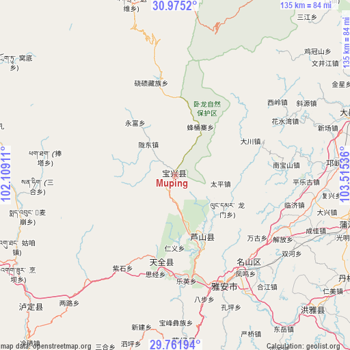
Muping GPS coordinates[2]
30° 22' 13.62" North, 102° 48' 44.028" East
| Map corner | latitude | longitude |
|---|---|---|
| Upper-left | 30.9752°, | 102.10911° |
| Center: | 30.37045°, | 102.81223° |
| Lower-right: | 29.76194°, | 103.51536° |
| Map W x H: | 134.9×134.9 km | = 83.8×83.8mi |
| max Lat: | 53.31946° ⇑50.6% North |
| Muping: | 30.37045° |
| min Lat: | ⇓49.4% South 18.22056° |
| min Long | Muping | max Long |
| 75.07348° | 102.81223° | 134.28917° |
| W 8.2%⇐ | ⇒91.8% E |
Elevation
Elevation of Muping is 1016 m = 3333 ft, and this is 531.2 m = 1743 ft above average elevation for this country.
| Max E: |
5622 m = 18445 ft | 14.5% |
| Muping | 1016 m 3333 ft | |
| Avg. | 484.8 m = 1591 ft | |
Min E: |
-3 m = -10 ft | 85.5% |
See also: China elevation on elevation.city.
Geographical zone
Muping is located in North temperate zone (between Tropic of Cancer and the Arctic Circle). Distance of this Northern Tropic circle is 771 km =479.1 mi to South.| Distance of | km | miles | from Muping |
|---|---|---|---|
| North Pole | 6630.2 | 4119.8 | to North |
| Arctic Circle | 4024.3 | 2500.6 | to North |
| Tropic Cancer | 771 | 479.1 | to South |
| Equator | 3376.9 | 2098.3 | to South |


Nearby cities:
15 places around Muping: (largest is in red/bold)
• Dongsheng
108.7 km =67.5 mi,  77°
77°
• Guangsheng
91.6 km =56.9 mi,  63°
63°
• Kangding
91.8 km =57 mi,  243°
243°
• Linqiong
62.4 km =38.8 mi,  85°
85°
• Liucheng
104.8 km =65.1 mi,  69°
69°
• Luqiao
74.1 km =46 mi,  228°
228°
• Meixing
82.2 km =51.1 mi,  328°
328°
• Nan’an
92.5 km =57.5 mi,  134°
134°
• Pitong
113.5 km =70.5 mi, 64°
• Suishan
106.7 km =66.3 mi,  142°
142°
• Wujin
96.1 km =59.7 mi, 87°
• Yancheng
100.7 km =62.6 mi, 133°
• Yucheng
46.4 km =28.8 mi,  157°
157°
• Zhanggu
104.3 km =64.8 mi,  302°
302°
• Zitong
94.6 km =58.8 mi, 63°
Sources, notices
• [Note1] Compared only with cities in China existing in our database
• [Src1] Map data: © OpenStreetMap contributors (CC-BY-SA)
• [Src2] Other city data from geonames.org with taken over terms of usage.
• [Src3] Geographical zone / Annual Mean Temperature by Robert A. Rohde @ Wikipedia
