Linqiong geodata
Linqiong (Sichuan) is a populated place(s); located in China in Asia/Shanghai (GMT+8) time zone. With population of 55,587 people, there are 785 cities with bigger population in this country. Compared to other cities in China, 50.3% of cities are located further ↑North; 91% of cities are located further →East and 74.5% of cities have lower elevation than Linqiong. Note1


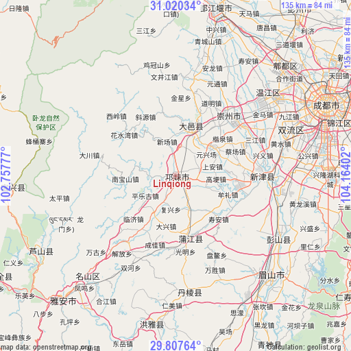
Linqiong GPS coordinates[2]
30° 24' 57.132" North, 103° 27' 39.204" East
| Map corner | latitude | longitude |
|---|---|---|
| Upper-left | 31.02034°, | 102.75777° |
| Center: | 30.41587°, | 103.46089° |
| Lower-right: | 29.80764°, | 104.16402° |
| Map W x H: | 134.8×134.8 km | = 83.8×83.8mi |
| max Lat: | 53.31946° ⇑50.3% North |
| Linqiong: | 30.41587° |
| min Lat: | ⇓49.7% South 18.22056° |
| min Long | Linqiong | max Long |
| 75.07348° | 103.46089° | 134.28917° |
| W 9%⇐ | ⇒91% E |
Elevation
Elevation of Linqiong is 511 m = 1677 ft, and this is 26.2 m = 86 ft above average elevation for this country.
| Max E: |
5622 m = 18445 ft | 25.5% |
| Linqiong | 511 m 1677 ft | |
| Avg. | 484.8 m = 1591 ft | |
Min E: |
-3 m = -10 ft | 74.5% |
See also: Linqiong elevation on elevation.city.
Geographical zone
Linqiong is located in North temperate zone (between Tropic of Cancer and the Arctic Circle). Distance of this Northern Tropic circle is 776 km =482.2 mi to South.| Distance of | km | miles | from Linqiong |
|---|---|---|---|
| North Pole | 6625.1 | 4116.6 | to North |
| Arctic Circle | 4019.2 | 2497.4 | to North |
| Tropic Cancer | 776 | 482.2 | to South |
| Equator | 3381.9 | 2101.4 | to South |


Nearby cities:
15 places around Linqiong: (largest is in red/bold)
• Chengdu
64.4 km =40 mi,  64°
64°
• Dongsheng
47.5 km =29.5 mi,  68°
68°
• Guangsheng
40.9 km =25.4 mi,  29°
29°
• Liucheng
48 km =29.8 mi,  48°
48°
• Longquan
79.1 km =49.2 mi,  78°
78°
• Muping
62.4 km =38.8 mi,  265°
265°
• Nan’an
70.4 km =43.7 mi,  177°
177°
• Pitong
59.6 km =37 mi,  42°
42°
• Tianpeng
78.2 km =48.6 mi, 35°
• Wenlin
80.1 km =49.8 mi,  125°
125°
• Wujin
33.8 km =21 mi,  90°
90°
• Xipu
61.8 km =38.4 mi, 52°
• Yancheng
75.4 km =46.9 mi,  172°
172°
• Yucheng
65.3 km =40.6 mi,  222°
222°
• Zitong
43.5 km =27 mi, 31°
Sources, notices
• [Note1] Compared only with cities in China existing in our database
• [Src1] Map data: © OpenStreetMap contributors (CC-BY-SA)
• [Src2] Other city data from geonames.org with taken over terms of usage.
• [Src3] Geographical zone / Annual Mean Temperature by Robert A. Rohde @ Wikipedia
