Shirong geodata
Shirong (Sichuan) is a seat of a third-order administrative division; located in China in Asia/Shanghai (GMT+8) time zone. In our database, there are 1268 cities with bigger population. Compared to other cities in China, 61.3% of cities are located further ↑North; 92.1% of cities are located further →East and 83.2% of cities have lower elevation than Shirong. Note1


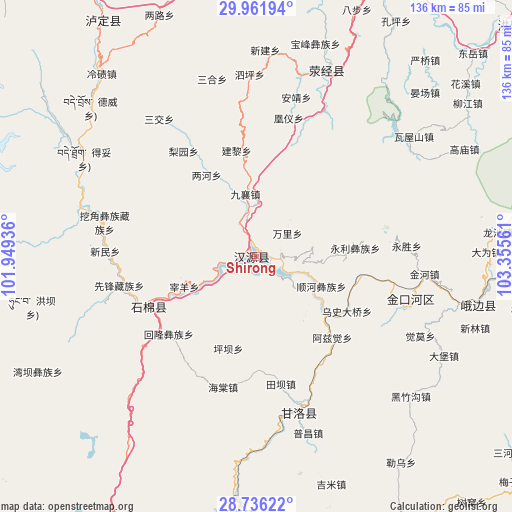
Shirong GPS coordinates[2]
29° 21' 3.312" North, 102° 39' 8.928" East
| Map corner | latitude | longitude |
|---|---|---|
| Upper-left | 29.96194°, | 101.94936° |
| Center: | 29.35092°, | 102.65248° |
| Lower-right: | 28.73622°, | 103.35561° |
| Map W x H: | 136.3×136.3 km | = 84.7×84.7mi |
| max Lat: | 53.31946° ⇑61.3% North |
| Shirong: | 29.35092° |
| min Lat: | ⇓38.7% South 18.22056° |
| min Long | Shirong | max Long |
| 75.07348° | 102.65248° | 134.28917° |
| W 7.9%⇐ | ⇒92.1% E |
Elevation
Elevation of Shirong is 861 m = 2825 ft, and this is 376.2 m = 1234 ft above average elevation for this country.
| Max E: |
5622 m = 18445 ft | 16.8% |
| Shirong | 861 m 2825 ft | |
| Avg. | 484.8 m = 1591 ft | |
Min E: |
-3 m = -10 ft | 83.2% |
See also: China elevation on elevation.city.
Geographical zone
Shirong is located in North temperate zone (between Tropic of Cancer and the Arctic Circle). Distance of this Northern Tropic circle is 657.6 km =408.6 mi to South.| Distance of | km | miles | from Shirong |
|---|---|---|---|
| North Pole | 6743.5 | 4190.2 | to North |
| Arctic Circle | 4137.7 | 2571 | to North |
| Tropic Cancer | 657.6 | 408.6 | to South |
| Equator | 3263.5 | 2027.8 | to South |


Nearby cities:
15 places around Shirong: (largest is in red/bold)
• Chengxiang
100.5 km =62.4 mi,  207°
207°
• Hepingyizu
43.3 km =26.9 mi,  105°
105°
• Kangding
98.8 km =61.4 mi,  317°
317°
• Leshan
110.1 km =68.4 mi,  77°
77°
• Luqiao
76.4 km =47.5 mi,  327°
327°
• Minjian
103.3 km =64.2 mi,  122°
122°
• Nan’an
94.5 km =58.7 mi,  59°
59°
• Shaping
61 km =37.9 mi,  102°
102°
• Shawan
86.6 km =53.8 mi,  85°
85°
• Suishan
85.6 km =53.2 mi,  70°
70°
• Xinmian
29.9 km =18.6 mi,  245°
245°
• Xinshiba
43.8 km =27.2 mi,  164°
164°
• Yancheng
98.6 km =61.3 mi, 63°
• Yucheng
78.1 km =48.5 mi,  25°
25°
• Yuecheng
80.1 km =49.8 mi,  190°
190°
Sources, notices
• [Note1] Compared only with cities in China existing in our database
• [Src1] Map data: © OpenStreetMap contributors (CC-BY-SA)
• [Src2] Other city data from geonames.org with taken over terms of usage.
• [Src3] Geographical zone / Annual Mean Temperature by Robert A. Rohde @ Wikipedia
