Pucun geodata
Pucun (Shaanxi) is a seat of a fourth-order administrative division; located in China in Asia/Shanghai (GMT+8) time zone. In our database, there are 1268 cities with bigger population. Compared to other cities in China, 72.6% of cities are located further ↓South; 81.4% of cities are located further →East and 81.5% of cities have lower elevation than Pucun. Note1


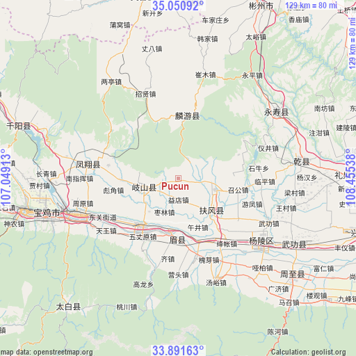
Pucun GPS coordinates[2]
34° 28' 23.844" North, 107° 45' 8.1" East
| Map corner | latitude | longitude |
|---|---|---|
| Upper-left | 35.05092°, | 107.04913° |
| Center: | 34.47329°, | 107.75225° |
| Lower-right: | 33.89163°, | 108.45538° |
| Map W x H: | 128.9×128.9 km | = 80.1×80.1mi |
| max Lat: | 53.31946° ⇑27.4% North |
| Pucun: | 34.47329° |
| min Lat: | ⇓72.6% South 18.22056° |
| min Long | Pucun | max Long |
| 75.07348° | 107.75225° | 134.28917° |
| W 18.6%⇐ | ⇒81.4% E |
Elevation
Elevation of Pucun is 768 m = 2520 ft, and this is 283.2 m = 929 ft above average elevation for this country.
| Max E: |
5622 m = 18445 ft | 18.5% |
| Pucun | 768 m 2520 ft | |
| Avg. | 484.8 m = 1591 ft | |
Min E: |
-3 m = -10 ft | 81.5% |
See also: China elevation on elevation.city.
Geographical zone
Pucun is located in North temperate zone (between Tropic of Cancer and the Arctic Circle). Distance of this Northern Tropic circle is 1227.2 km =762.5 mi to South.| Distance of | km | miles | from Pucun |
|---|---|---|---|
| North Pole | 6174 | 3836.3 | to North |
| Arctic Circle | 3568.1 | 2217.1 | to North |
| Tropic Cancer | 1227.2 | 762.5 | to South |
| Equator | 3833.1 | 2381.8 | to South |


Nearby cities:
15 places around Pucun: (largest is in red/bold)
• Daying
10.5 km =6.5 mi,  227°
227°
• Famen
14 km =8.7 mi,  106°
106°
• Fengming
12.8 km =8 mi,  253°
253°
• Fufeng
16.8 km =10.4 mi,  138°
138°
• Gujun
6.9 km =4.3 mi,  236°
236°
• Jingdang
6.8 km =4.2 mi,  73°
73°
• Majia
18.6 km =11.6 mi,  192°
192°
• Nanyang
16.4 km =10.2 mi,  84°
84°
• Qinghua
9.3 km =5.8 mi,  124°
124°
• Tiandu
19.3 km =12 mi, 83°
• Wujing
18.8 km =11.7 mi,  159°
159°
• Yidian
7.7 km =4.8 mi,  179°
179°
• Yongchuan
16 km =9.9 mi,  221°
221°
• Zaolin
13.2 km =8.2 mi,  202°
202°
• Zhujiazhuang
2.6 km =1.6 mi,  92°
92°
Sources, notices
• [Note1] Compared only with cities in China existing in our database
• [Src1] Map data: © OpenStreetMap contributors (CC-BY-SA)
• [Src2] Other city data from geonames.org with taken over terms of usage.
• [Src3] Geographical zone / Annual Mean Temperature by Robert A. Rohde @ Wikipedia
