Gongbuxue geodata
Gongbuxue (Tibet) is a seat of a fourth-order administrative division; located in China in Asia/Shanghai (GMT+8) time zone. In our database, there are 1268 cities with bigger population. Compared to other cities in China, 66.8% of cities are located further ↑North; 96.9% of cities are located further →East and 99.5% of cities have lower elevation than Gongbuxue. Note1


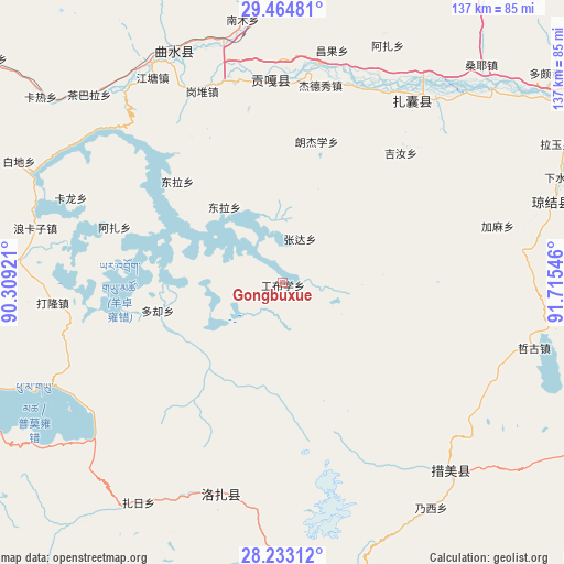
Gongbuxue GPS coordinates[2]
28° 51' 2.844" North, 91° 0' 44.388" East
| Map corner | latitude | longitude |
|---|---|---|
| Upper-left | 29.46481°, | 90.30921° |
| Center: | 28.85079°, | 91.01233° |
| Lower-right: | 28.23312°, | 91.71546° |
| Map W x H: | 137×137 km | = 85.1×85.1mi |
| max Lat: | 53.31946° ⇑66.8% North |
| Gongbuxue: | 28.85079° |
| min Lat: | ⇓33.2% South 18.22056° |
| min Long | Gongbuxue | max Long |
| 75.07348° | 91.01233° | 134.28917° |
| W 3.1%⇐ | ⇒96.9% E |
Elevation
Elevation of Gongbuxue is 4462 m = 14639 ft, and this is 3977.2 m = 13049 ft above average elevation for this country.
| Max E: |
5622 m = 18445 ft | 0.5% |
| Gongbuxue | 4462 m 14639 ft | |
| Avg. | 484.8 m = 1591 ft | |
Min E: |
-3 m = -10 ft | 99.5% |
See also: China elevation on elevation.city.
Geographical zone
Gongbuxue is located in North temperate zone (between Tropic of Cancer and the Arctic Circle). Distance of this Northern Tropic circle is 602 km =374.1 mi to South.| Distance of | km | miles | from Gongbuxue |
|---|---|---|---|
| North Pole | 6799.2 | 4224.8 | to North |
| Arctic Circle | 4193.3 | 2605.6 | to North |
| Tropic Cancer | 602 | 374.1 | to South |
| Equator | 3207.9 | 1993.3 | to South |


Nearby cities:
15 places around Gongbuxue: (largest is in red/bold)
• Bianba
78 km =48.5 mi,  160°
160°
• Caina
65.8 km =40.9 mi,  355°
355°
• Changzhug
83.1 km =51.6 mi,  62°
62°
• Chaqi
58.5 km =36.4 mi,  40°
40°
• Dagar
62.9 km =39.1 mi,  329°
329°
• Dongla
35.9 km =22.3 mi,  313°
313°
• Dopozhang
83.4 km =51.8 mi,  51°
51°
• Karlung
55.2 km =34.3 mi,  291°
291°
• Konggar
49.3 km =30.6 mi, 357°
• Layu
71 km =44.1 mi, 62°
• Naidong
85.8 km =53.3 mi, 59°
• Nam
69.1 km =42.9 mi,  353°
353°
• Niu
79.8 km =49.6 mi,  1°
1°
• Pozhang
85.1 km =52.9 mi,  69°
69°
• Pumaqangtang
83.6 km =51.9 mi,  250°
250°
Sources, notices
• [Note1] Compared only with cities in China existing in our database
• [Src1] Map data: © OpenStreetMap contributors (CC-BY-SA)
• [Src2] Other city data from geonames.org with taken over terms of usage.
• [Src3] Geographical zone / Annual Mean Temperature by Robert A. Rohde @ Wikipedia
