Dopozhang geodata
Dopozhang (Tibet) is a seat of a fourth-order administrative division; located in China in Asia/Shanghai (GMT+8) time zone. In our database, there are 1268 cities with bigger population. Compared to other cities in China, 61.8% of cities are located further ↑North; 96.8% of cities are located further →East and 98% of cities have lower elevation than Dopozhang. Note1


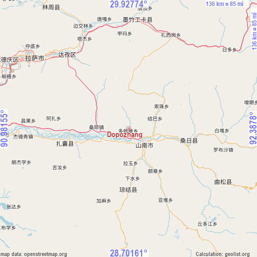
Dopozhang GPS coordinates[2]
29° 18' 59.472" North, 91° 41' 4.812" East
| Map corner | latitude | longitude |
|---|---|---|
| Upper-left | 29.92774°, | 90.98155° |
| Center: | 29.31652°, | 91.68467° |
| Lower-right: | 28.70161°, | 92.3878° |
| Map W x H: | 136.3×136.3 km | = 84.7×84.7mi |
| max Lat: | 53.31946° ⇑61.8% North |
| Dopozhang: | 29.31652° |
| min Lat: | ⇓38.2% South 18.22056° |
| min Long | Dopozhang | max Long |
| 75.07348° | 91.68467° | 134.28917° |
| W 3.2%⇐ | ⇒96.8% E |
Elevation
Elevation of Dopozhang is 3684 m = 12087 ft, and this is 3199.2 m = 10496 ft above average elevation for this country.
| Max E: |
5622 m = 18445 ft | 2% |
| Dopozhang | 3684 m 12087 ft | |
| Avg. | 484.8 m = 1591 ft | |
Min E: |
-3 m = -10 ft | 98% |
See also: China elevation on elevation.city.
Geographical zone
Dopozhang is located in North temperate zone (between Tropic of Cancer and the Arctic Circle). Distance of this Northern Tropic circle is 653.8 km =406.3 mi to South.| Distance of | km | miles | from Dopozhang |
|---|---|---|---|
| North Pole | 6747.4 | 4192.6 | to North |
| Arctic Circle | 4141.5 | 2573.4 | to North |
| Tropic Cancer | 653.8 | 406.3 | to South |
| Equator | 3259.7 | 2025.5 | to South |


Nearby cities:
15 places around Dopozhang: (largest is in red/bold)
• Caina
72.1 km =44.8 mi,  280°
280°
• Changzhug
16.1 km =10 mi,  148°
148°
• Chaqi
28.3 km =17.6 mi,  255°
255°
• Gongbuxue
83.4 km =51.8 mi,  231°
231°
• Jibenggang
66 km =41 mi,  305°
305°
• Konggar
67.7 km =42.1 mi,  267°
267°
• Layu
19 km =11.8 mi,  187°
187°
• Lhasa
67.7 km =42.1 mi,  303°
303°
• Naidong
11.8 km =7.3 mi,  133°
133°
• Nam
75.1 km =46.7 mi, 282°
• Ngarrab
89.9 km =55.9 mi,  102°
102°
• Niu
69.3 km =43.1 mi,  293°
293°
• Norbusa
51.4 km =31.9 mi, 102°
• Pozhang
26.8 km =16.7 mi, 147°
• Sozhug
21.8 km =13.5 mi,  56°
56°
Sources, notices
• [Note1] Compared only with cities in China existing in our database
• [Src1] Map data: © OpenStreetMap contributors (CC-BY-SA)
• [Src2] Other city data from geonames.org with taken over terms of usage.
• [Src3] Geographical zone / Annual Mean Temperature by Robert A. Rohde @ Wikipedia
