Sozhug geodata
Sozhug (Tibet) is a seat of a fourth-order administrative division; located in China in Asia/Shanghai (GMT+8) time zone. In our database, there are 1268 cities with bigger population. Compared to other cities in China, 60.6% of cities are located further ↑North; 96.8% of cities are located further →East and 98.2% of cities have lower elevation than Sozhug. Note1


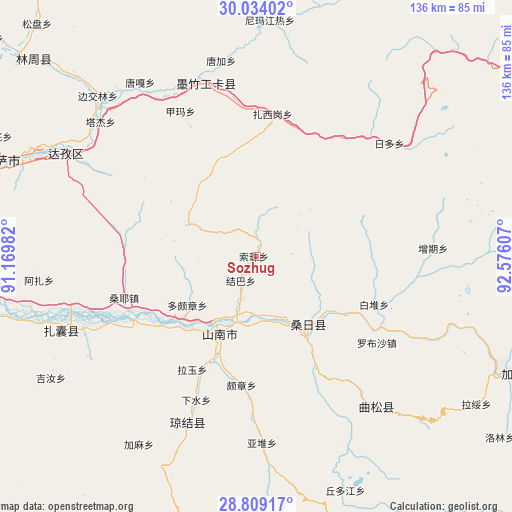
Sozhug GPS coordinates[2]
29° 25' 24.384" North, 91° 52' 22.584" East
| Map corner | latitude | longitude |
|---|---|---|
| Upper-left | 30.03402°, | 91.16982° |
| Center: | 29.42344°, | 91.87294° |
| Lower-right: | 28.80917°, | 92.57607° |
| Map W x H: | 136.2×136.2 km | = 84.6×84.6mi |
| max Lat: | 53.31946° ⇑60.6% North |
| Sozhug: | 29.42344° |
| min Lat: | ⇓39.4% South 18.22056° |
| min Long | Sozhug | max Long |
| 75.07348° | 91.87294° | 134.28917° |
| W 3.2%⇐ | ⇒96.8% E |
Elevation
Elevation of Sozhug is 3814 m = 12513 ft, and this is 3329.2 m = 10923 ft above average elevation for this country.
| Max E: |
5622 m = 18445 ft | 1.8% |
| Sozhug | 3814 m 12513 ft | |
| Avg. | 484.8 m = 1591 ft | |
Min E: |
-3 m = -10 ft | 98.2% |
See also: China elevation on elevation.city.
Geographical zone
Sozhug is located in North temperate zone (between Tropic of Cancer and the Arctic Circle). Distance of this Northern Tropic circle is 665.7 km =413.6 mi to South.| Distance of | km | miles | from Sozhug |
|---|---|---|---|
| North Pole | 6735.5 | 4185.2 | to North |
| Arctic Circle | 4129.6 | 2566 | to North |
| Tropic Cancer | 665.7 | 413.6 | to South |
| Equator | 3271.6 | 2032.9 | to South |


Nearby cities:
15 places around Sozhug: (largest is in red/bold)
• Caina
89 km =55.3 mi,  271°
271°
• Changzhug
27.4 km =17 mi,  200°
200°
• Chaqi
49.5 km =30.8 mi,  247°
247°
• Cuijiu
81.3 km =50.5 mi,  88°
88°
• Dopozhang
21.8 km =13.5 mi,  236°
236°
• Jibenggang
76.7 km =47.7 mi,  289°
289°
• Konggar
87 km =54.1 mi,  260°
260°
• Layu
37.1 km =23.1 mi,  214°
214°
• Lhasa
78.9 km =49 mi, 288°
• Naidong
22.3 km =13.9 mi, 205°
• Ngarrab
76.1 km =47.3 mi,  114°
114°
• Niu
83.1 km =51.6 mi,  281°
281°
• Norbusa
39.3 km =24.4 mi,  125°
125°
• Pozhang
34.6 km =21.5 mi,  186°
186°
• Rinang
85 km =52.8 mi,  122°
122°
Sources, notices
• [Note1] Compared only with cities in China existing in our database
• [Src1] Map data: © OpenStreetMap contributors (CC-BY-SA)
• [Src2] Other city data from geonames.org with taken over terms of usage.
• [Src3] Geographical zone / Annual Mean Temperature by Robert A. Rohde @ Wikipedia
