Wenquan geodata
Wenquan (Inner Mongolia) is a seat of a third-order administrative division; located in China in Asia/Shanghai (GMT+8) time zone. In our database, there are 1268 cities with bigger population. Compared to other cities in China, 97.3% of cities are located further ↓South; 81.6% of cities are located further ←West and 87.4% of cities have lower elevation than Wenquan. Note1


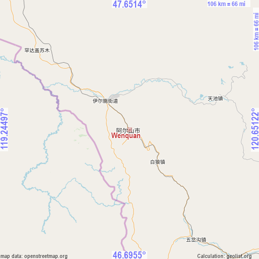
Wenquan GPS coordinates[2]
47° 10' 32.16" North, 119° 56' 53.124" East
| Map corner | latitude | longitude |
|---|---|---|
| Upper-left | 47.6514°, | 119.24497° |
| Center: | 47.1756°, | 119.94809° |
| Lower-right: | 46.6955°, | 120.65122° |
| Map W x H: | 106.3×106.3 km | = 66.1×66.1mi |
| max Lat: | 53.31946° ⇑2.7% North |
| Wenquan: | 47.1756° |
| min Lat: | ⇓97.3% South 18.22056° |
| min Long | Wenquan | max Long |
| 75.07348° | 119.94809° | 134.28917° |
| W 81.6%⇐ | ⇒18.4% E |
Elevation
Elevation of Wenquan is 1148 m = 3766 ft, and this is 663.2 m = 2176 ft above average elevation for this country.
| Max E: |
5622 m = 18445 ft | 12.6% |
| Wenquan | 1148 m 3766 ft | |
| Avg. | 484.8 m = 1591 ft | |
Min E: |
-3 m = -10 ft | 87.4% |
See also: China elevation on elevation.city.
Geographical zone
Wenquan is located in North temperate zone (between Tropic of Cancer and the Arctic Circle). Distance of this North polar circle is 2155.7 km =1339.5 mi to North.| Distance of | km | miles | from Wenquan |
|---|---|---|---|
| North Pole | 4761.6 | 2958.7 | to North |
| Arctic Circle | 2155.7 | 1339.5 | to North |
| Tropic Cancer | 2639.5 | 1640.1 | to South |
| Equator | 5245.4 | 3259.3 | to South |


Nearby cities:
15 places around Wenquan: (largest is in red/bold)
• Alatan Hada
90.9 km =56.5 mi,  343°
343°
• Chaihe
110.6 km =68.7 mi,  67°
67°
• Haduohe
155.5 km =96.6 mi,  87°
87°
• Handgai
54.8 km =34.1 mi,  311°
311°
• Haoraoshan
127.5 km =79.2 mi, 88°
• Honghua’erji
121.8 km =75.7 mi,  1°
1°
• Mingshuihe
81.5 km =50.6 mi,  134°
134°
• Shumugou
129.6 km =80.5 mi,  149°
149°
• Sugehe
146.3 km =90.9 mi,  41°
41°
• Ta’erqi
129.4 km =80.4 mi,  46°
46°
• Wenquan
1.6 km =1 mi,  58°
58°
• Wuchagou
55.5 km =34.5 mi, 150°
• Wu’erbu Baolige
120.1 km =74.6 mi,  325°
325°
• Yiminhe
157.4 km =97.8 mi,  355°
355°
• Yirshi
20.4 km =12.7 mi, 312°
Sources, notices
• [Note1] Compared only with cities in China existing in our database
• [Src1] Map data: © OpenStreetMap contributors (CC-BY-SA)
• [Src2] Other city data from geonames.org with taken over terms of usage.
• [Src3] Geographical zone / Annual Mean Temperature by Robert A. Rohde @ Wikipedia
