Tarma geodata
Tarma (Tibet) is a seat of a fourth-order administrative division; located in China in Asia/Shanghai (GMT+8) time zone. In our database, there are 1268 cities with bigger population. Compared to other cities in China, 51.9% of cities are located further ↓South; 97.6% of cities are located further →East and 100% of cities have lower elevation than Tarma. Note1


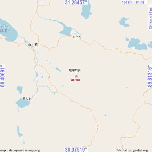
Tarma GPS coordinates[2]
30° 40' 54.372" North, 89° 6' 36.108" East
| Map corner | latitude | longitude |
|---|---|---|
| Upper-left | 31.28457°, | 88.40691° |
| Center: | 30.68177°, | 89.11003° |
| Lower-right: | 30.07519°, | 89.81316° |
| Map W x H: | 134.5×134.5 km | = 83.6×83.6mi |
| max Lat: | 53.31946° ⇑48.1% North |
| Tarma: | 30.68177° |
| min Lat: | ⇓51.9% South 18.22056° |
| min Long | Tarma | max Long |
| 75.07348° | 89.11003° | 134.28917° |
| W 2.4%⇐ | ⇒97.6% E |
Elevation
Elevation of Tarma is 4976 m = 16325 ft, and this is 4491.2 m = 14735 ft above average elevation for this country.
| Max E: |
5622 m = 18445 ft | 0% |
| Tarma | 4976 m 16325 ft | |
| Avg. | 484.8 m = 1591 ft | |
Min E: |
-3 m = -10 ft | 100% |
See also: China elevation on elevation.city.
Geographical zone
Tarma is located in North temperate zone (between Tropic of Cancer and the Arctic Circle). Distance of this Northern Tropic circle is 805.6 km =500.6 mi to South.| Distance of | km | miles | from Tarma |
|---|---|---|---|
| North Pole | 6595.6 | 4098.3 | to North |
| Arctic Circle | 3989.7 | 2479.1 | to North |
| Tropic Cancer | 805.6 | 500.6 | to South |
| Equator | 3411.5 | 2119.8 | to South |


Nearby cities:
15 places around Tarma: (largest is in red/bold)
• Baoji
108.1 km =67.2 mi,  71°
71°
• Dana
109.3 km =67.9 mi,  173°
173°
• Deqing
98.7 km =61.3 mi,  99°
99°
• Gyamco
93.1 km =57.8 mi,  175°
175°
• Jiajuedibu
53.4 km =33.2 mi,  301°
301°
• Lhabupu
94.6 km =58.8 mi,  163°
163°
• Maiba
36.4 km =22.6 mi,  357°
357°
• Maintang
102 km =63.4 mi,  37°
37°
• Namling
110.8 km =68.8 mi, 180°
• Pundam
86.5 km =53.7 mi, 179°
• Qum
116.8 km =72.6 mi, 184°
• Ratang
110 km =68.4 mi, 166°
• Rendui
67.6 km =42 mi, 180°
• Xinji
69.7 km =43.3 mi, 97°
• Xungmai
73.8 km =45.9 mi,  352°
352°
Sources, notices
• [Note1] Compared only with cities in China existing in our database
• [Src1] Map data: © OpenStreetMap contributors (CC-BY-SA)
• [Src2] Other city data from geonames.org with taken over terms of usage.
• [Src3] Geographical zone / Annual Mean Temperature by Robert A. Rohde @ Wikipedia
