Xinji geodata
Xinji (Tibet) is a seat of a fourth-order administrative division; located in China in Asia/Shanghai (GMT+8) time zone. In our database, there are 1268 cities with bigger population. Compared to other cities in China, 51.1% of cities are located further ↓South; 97.2% of cities are located further →East and 99.9% of cities have lower elevation than Xinji. Note1


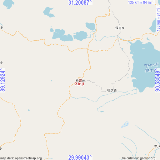
Xinji GPS coordinates[2]
30° 35' 51.144" North, 89° 49' 56.496" East
| Map corner | latitude | longitude |
|---|---|---|
| Upper-left | 31.20087°, | 89.12924° |
| Center: | 30.59754°, | 89.83236° |
| Lower-right: | 29.99043°, | 90.53549° |
| Map W x H: | 134.6×134.6 km | = 83.6×83.6mi |
| max Lat: | 53.31946° ⇑48.9% North |
| Xinji: | 30.59754° |
| min Lat: | ⇓51.1% South 18.22056° |
| min Long | Xinji | max Long |
| 75.07348° | 89.83236° | 134.28917° |
| W 2.8%⇐ | ⇒97.2% E |
Elevation
Elevation of Xinji is 4892 m = 16050 ft, and this is 4407.2 m = 14459 ft above average elevation for this country.
| Max E: |
5622 m = 18445 ft | 0.099999999999994% |
| Xinji | 4892 m 16050 ft | |
| Avg. | 484.8 m = 1591 ft | |
Min E: |
-3 m = -10 ft | 99.9% |
See also: China elevation on elevation.city.
Geographical zone
Xinji is located in North temperate zone (between Tropic of Cancer and the Arctic Circle). Distance of this Northern Tropic circle is 796.2 km =494.7 mi to South.| Distance of | km | miles | from Xinji |
|---|---|---|---|
| North Pole | 6604.9 | 4104.1 | to North |
| Arctic Circle | 3999 | 2484.9 | to North |
| Tropic Cancer | 796.2 | 494.7 | to South |
| Equator | 3402.1 | 2114 | to South |


Nearby cities:
15 places around Xinji: (largest is in red/bold)
• Baoji
55.3 km =34.4 mi,  37°
37°
• Dazi
112.6 km =70 mi,  190°
190°
• Deqing
29.1 km =18.1 mi,  105°
105°
• Dêqên
110.6 km =68.7 mi,  129°
129°
• Gyamco
104 km =64.6 mi,  216°
216°
• Lhabupu
92.3 km =57.4 mi,  207°
207°
• Maiba
83.9 km =52.1 mi,  303°
303°
• Maintang
91 km =56.5 mi,  355°
355°
• Pubu
90.4 km =56.2 mi,  10°
10°
• Pundam
103.3 km =64.2 mi, 221°
• Qinglung
101.3 km =62.9 mi,  51°
51°
• Ratang
107.5 km =66.8 mi,  204°
204°
• Rendui
90.9 km =56.5 mi,  230°
230°
• Suojin
110 km =68.4 mi, 193°
• Tarma
69.7 km =43.3 mi,  277°
277°
Sources, notices
• [Note1] Compared only with cities in China existing in our database
• [Src1] Map data: © OpenStreetMap contributors (CC-BY-SA)
• [Src2] Other city data from geonames.org with taken over terms of usage.
• [Src3] Geographical zone / Annual Mean Temperature by Robert A. Rohde @ Wikipedia
