Deqing geodata
Deqing (Tibet) is a seat of a fourth-order administrative division; located in China in Asia/Shanghai (GMT+8) time zone. In our database, there are 1268 cities with bigger population. Compared to other cities in China, 50.6% of cities are located further ↓South; 97.2% of cities are located further →East and 99.9% of cities have lower elevation than Deqing. Note1


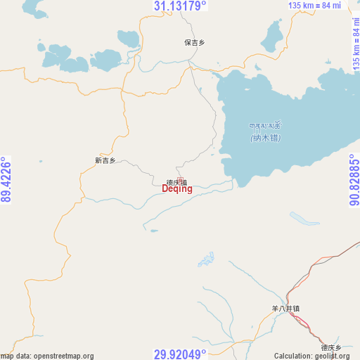
Deqing GPS coordinates[2]
30° 31' 40.908" North, 90° 7' 32.592" East
| Map corner | latitude | longitude |
|---|---|---|
| Upper-left | 31.13179°, | 89.4226° |
| Center: | 30.52803°, | 90.12572° |
| Lower-right: | 29.92049°, | 90.82885° |
| Map W x H: | 134.7×134.7 km | = 83.7×83.7mi |
| max Lat: | 53.31946° ⇑49.4% North |
| Deqing: | 30.52803° |
| min Lat: | ⇓50.6% South 18.22056° |
| min Long | Deqing | max Long |
| 75.07348° | 90.12572° | 134.28917° |
| W 2.8%⇐ | ⇒97.2% E |
Elevation
Elevation of Deqing is 4799 m = 15745 ft, and this is 4314.2 m = 14154 ft above average elevation for this country.
| Max E: |
5622 m = 18445 ft | 0.099999999999994% |
| Deqing | 4799 m 15745 ft | |
| Avg. | 484.8 m = 1591 ft | |
Min E: |
-3 m = -10 ft | 99.9% |
See also: China elevation on elevation.city.
Geographical zone
Deqing is located in North temperate zone (between Tropic of Cancer and the Arctic Circle). Distance of this Northern Tropic circle is 788.5 km =490 mi to South.| Distance of | km | miles | from Deqing |
|---|---|---|---|
| North Pole | 6612.7 | 4108.9 | to North |
| Arctic Circle | 4006.8 | 2489.7 | to North |
| Tropic Cancer | 788.5 | 490 | to South |
| Equator | 3394.4 | 2109.2 | to South |


Nearby cities:
15 places around Deqing: (largest is in red/bold)
• Baoji
52.1 km =32.4 mi,  5°
5°
• Dazi
113.9 km =70.8 mi,  205°
205°
• Dêqên
84.9 km =52.8 mi,  137°
137°
• Lhabupu
102.7 km =63.8 mi,  224°
224°
• Maiba
111.9 km =69.5 mi,  298°
298°
• Maintang
104.6 km =65 mi,  340°
340°
• Nyima
108 km =67.1 mi,  55°
55°
• Pubu
97.2 km =60.4 mi,  353°
353°
• Pusum
114.4 km =71.1 mi,  178°
178°
• Qinglung
87.3 km =54.2 mi,  36°
36°
• Ratang
115.8 km =72 mi, 218°
• Rendui
110.3 km =68.5 mi,  242°
242°
• Suojin
113.1 km =70.3 mi, 208°
• Tarma
98.7 km =61.3 mi,  279°
279°
• Xinji
29.1 km =18.1 mi,  285°
285°
Sources, notices
• [Note1] Compared only with cities in China existing in our database
• [Src1] Map data: © OpenStreetMap contributors (CC-BY-SA)
• [Src2] Other city data from geonames.org with taken over terms of usage.
• [Src3] Geographical zone / Annual Mean Temperature by Robert A. Rohde @ Wikipedia
